You are here: Home > Network List > UW - Pacific Northwest Regional Seismic Network Stations List
> Station ABER Abernathy Mountain, Cowlitz County, WA, USA > Earthquake Result Viewer
ABER Abernathy Mountain, Cowlitz County, WA, USA - Earthquake Result Viewer
| Earthquake location: |
South Of Kermadec Islands |
| Earthquake latitude/longitude: |
-32.7/-179.3 |
| Earthquake time(UTC): |
2023/09/08 (251) 09:09:58 GMT |
| Earthquake Depth: |
90 km |
| Earthquake Magnitude: |
6.6 mww |
| Earthquake Catalog/Contributor: |
NEIC PDE/us |
|
| Network: |
UW Pacific Northwest Regional Seismic Network |
| Station: |
ABER Abernathy Mountain, Cowlitz County, WA, USA |
| Lat/Lon: |
46.34 N/123.10 W |
| Elevation: |
786 m |
|
| Distance: |
93.6 deg |
| Az: |
35.232 deg |
| Baz: |
224.582 deg |
| Ray Param: |
0.041176546 |
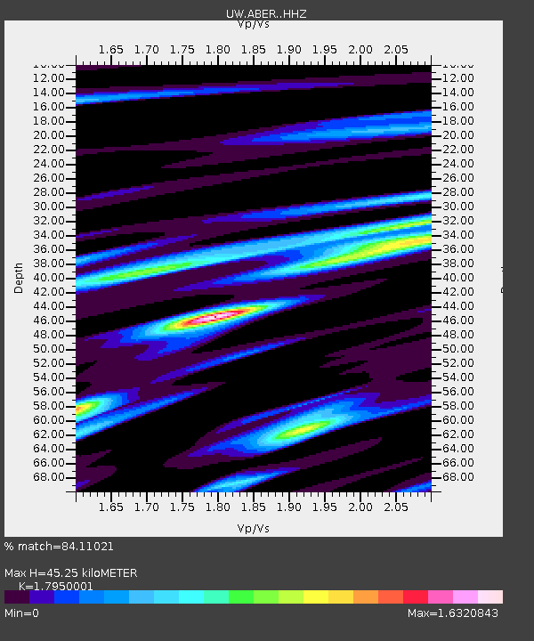
| Estimated Moho Depth: |
45.25 km |
| Estimated Crust Vp/Vs: |
1.80 |
| Assumed Crust Vp: |
6.566 km/s |
| Estimated Crust Vs: |
3.658 km/s |
| Estimated Crust Poisson's Ratio: |
0.27 |
|
| Radial Match: |
84.11021 % |
| Radial Bump: |
289 |
| Transverse Match: |
63.922604 % |
| Transverse Bump: |
269 |
| SOD ConfigId: |
31937991 |
| Insert Time: |
2023-09-22 09:55:52.639 +0000 |
| GWidth: |
2.5 |
| Max Bumps: |
400 |
| Tol: |
0.001 |
|

Signal To Noise
| Channel | StoN | STA | LTA |
| UW:ABER: :HHZ:20230908T09:22:33.449989Z | 9.485537 | 1.3647417E-6 | 1.4387608E-7 |
| UW:ABER: :HHN:20230908T09:22:33.449989Z | 3.3269405 | 5.6921976E-7 | 1.7109406E-7 |
| UW:ABER: :HHE:20230908T09:22:33.449989Z | 2.196477 | 5.0030036E-7 | 2.2777402E-7 |
| Arrivals |
| Ps | 5.6 SECOND |
| PpPs | 19 SECOND |
| PsPs/PpSs | 24 SECOND |


