You are here: Home > Network List > UW - Pacific Northwest Regional Seismic Network Stations List
> Station ABER Abernathy Mountain, Cowlitz County, WA, USA > Earthquake Result Viewer
ABER Abernathy Mountain, Cowlitz County, WA, USA - Earthquake Result Viewer
| Earthquake location: |
Near Coast Of Jalisco, Mexico |
| Earthquake latitude/longitude: |
19.5/-104.9 |
| Earthquake time(UTC): |
2023/09/08 (251) 16:37:17 GMT |
| Earthquake Depth: |
45 km |
| Earthquake Magnitude: |
5.7 mww |
| Earthquake Catalog/Contributor: |
NEIC PDE/us |
|
| Network: |
UW Pacific Northwest Regional Seismic Network |
| Station: |
ABER Abernathy Mountain, Cowlitz County, WA, USA |
| Lat/Lon: |
46.34 N/123.10 W |
| Elevation: |
786 m |
|
| Distance: |
30.7 deg |
| Az: |
334.832 deg |
| Baz: |
144.619 deg |
| Ray Param: |
0.07928119 |
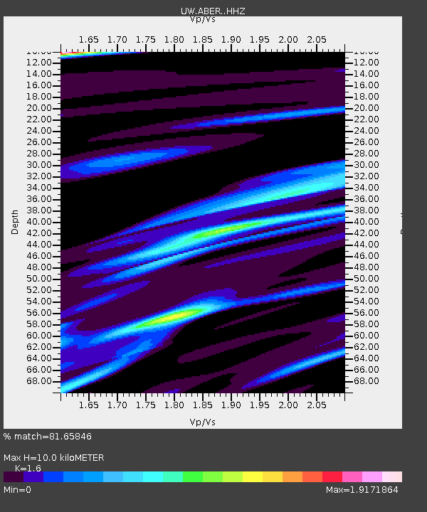
| Estimated Moho Depth: |
10.0 km |
| Estimated Crust Vp/Vs: |
1.60 |
| Assumed Crust Vp: |
6.566 km/s |
| Estimated Crust Vs: |
4.104 km/s |
| Estimated Crust Poisson's Ratio: |
0.18 |
|
| Radial Match: |
81.65846 % |
| Radial Bump: |
343 |
| Transverse Match: |
76.50839 % |
| Transverse Bump: |
380 |
| SOD ConfigId: |
31937991 |
| Insert Time: |
2023-09-22 16:59:33.694 +0000 |
| GWidth: |
2.5 |
| Max Bumps: |
400 |
| Tol: |
0.001 |
|

Signal To Noise
| Channel | StoN | STA | LTA |
| UW:ABER: :HHZ:20230908T16:42:57.309997Z | 19.218218 | 2.9226571E-6 | 1.5207742E-7 |
| UW:ABER: :HHN:20230908T16:42:57.309997Z | 6.7242794 | 1.5550941E-6 | 2.3126553E-7 |
| UW:ABER: :HHE:20230908T16:42:57.309997Z | 5.5800605 | 1.5473524E-6 | 2.773003E-7 |
| Arrivals |
| Ps | 1.0 SECOND |
| PpPs | 3.6 SECOND |
| PsPs/PpSs | 4.6 SECOND |


