You are here: Home > Network List > UW - Pacific Northwest Regional Seismic Network Stations List
> Station ABER Abernathy Mountain, Cowlitz County, WA, USA > Earthquake Result Viewer
ABER Abernathy Mountain, Cowlitz County, WA, USA - Earthquake Result Viewer
| Earthquake location: |
Morocco |
| Earthquake latitude/longitude: |
31.1/-8.4 |
| Earthquake time(UTC): |
2023/09/08 (251) 22:11:01 GMT |
| Earthquake Depth: |
19 km |
| Earthquake Magnitude: |
6.8 mww |
| Earthquake Catalog/Contributor: |
NEIC PDE/us |
|
| Network: |
UW Pacific Northwest Regional Seismic Network |
| Station: |
ABER Abernathy Mountain, Cowlitz County, WA, USA |
| Lat/Lon: |
46.34 N/123.10 W |
| Elevation: |
786 m |
|
| Distance: |
82.9 deg |
| Az: |
320.625 deg |
| Baz: |
51.762 deg |
| Ray Param: |
0.046526097 |
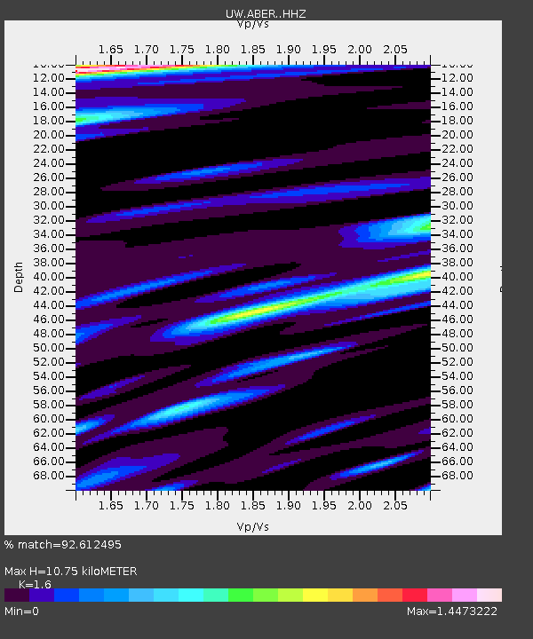
| Estimated Moho Depth: |
10.75 km |
| Estimated Crust Vp/Vs: |
1.60 |
| Assumed Crust Vp: |
6.566 km/s |
| Estimated Crust Vs: |
4.104 km/s |
| Estimated Crust Poisson's Ratio: |
0.18 |
|
| Radial Match: |
92.612495 % |
| Radial Bump: |
377 |
| Transverse Match: |
90.794914 % |
| Transverse Bump: |
400 |
| SOD ConfigId: |
31937991 |
| Insert Time: |
2023-09-22 22:52:40.304 +0000 |
| GWidth: |
2.5 |
| Max Bumps: |
400 |
| Tol: |
0.001 |
|

Signal To Noise
| Channel | StoN | STA | LTA |
| UW:ABER: :HHZ:20230908T22:22:53.620008Z | 9.1439085 | 1.0640862E-6 | 1.1637105E-7 |
| UW:ABER: :HHN:20230908T22:22:53.620008Z | 1.846277 | 3.157793E-7 | 1.7103571E-7 |
| UW:ABER: :HHE:20230908T22:22:53.620008Z | 3.118732 | 4.450151E-7 | 1.4269104E-7 |
| Arrivals |
| Ps | 1.0 SECOND |
| PpPs | 4.1 SECOND |
| PsPs/PpSs | 5.1 SECOND |


