You are here: Home > Network List > UW - Pacific Northwest Regional Seismic Network Stations List
> Station ABER Abernathy Mountain, Cowlitz County, WA, USA > Earthquake Result Viewer
ABER Abernathy Mountain, Cowlitz County, WA, USA - Earthquake Result Viewer
| Earthquake location: |
Chiapas, Mexico |
| Earthquake latitude/longitude: |
17.1/-95.0 |
| Earthquake time(UTC): |
2023/10/07 (280) 05:06:55 GMT |
| Earthquake Depth: |
108 km |
| Earthquake Magnitude: |
5.9 mww |
| Earthquake Catalog/Contributor: |
NEIC PDE/us |
|
| Network: |
UW Pacific Northwest Regional Seismic Network |
| Station: |
ABER Abernathy Mountain, Cowlitz County, WA, USA |
| Lat/Lon: |
46.34 N/123.10 W |
| Elevation: |
786 m |
|
| Distance: |
37.4 deg |
| Az: |
327.419 deg |
| Baz: |
131.978 deg |
| Ray Param: |
0.07581824 |
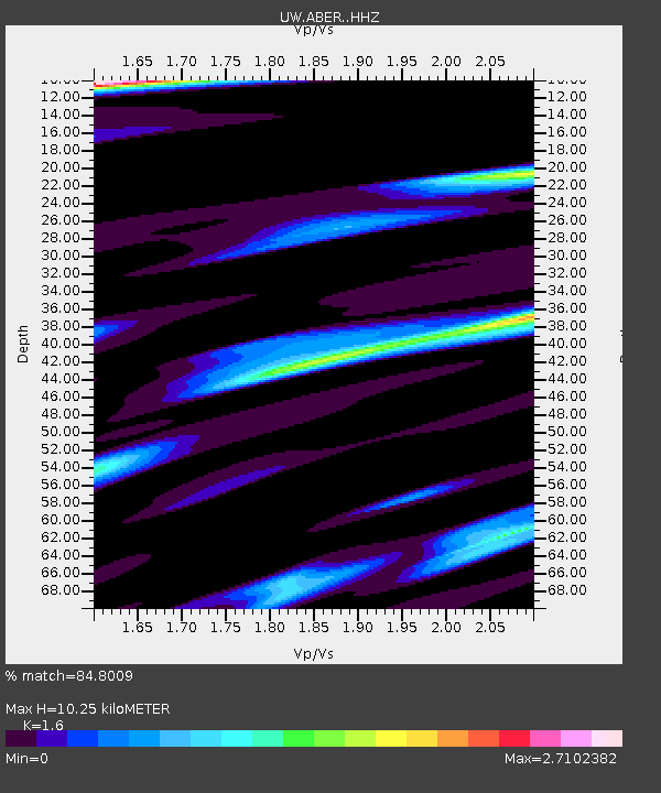
| Estimated Moho Depth: |
10.25 km |
| Estimated Crust Vp/Vs: |
1.60 |
| Assumed Crust Vp: |
6.566 km/s |
| Estimated Crust Vs: |
4.104 km/s |
| Estimated Crust Poisson's Ratio: |
0.18 |
|
| Radial Match: |
84.8009 % |
| Radial Bump: |
400 |
| Transverse Match: |
82.907234 % |
| Transverse Bump: |
400 |
| SOD ConfigId: |
31937991 |
| Insert Time: |
2023-10-21 05:26:32.289 +0000 |
| GWidth: |
2.5 |
| Max Bumps: |
400 |
| Tol: |
0.001 |
|

Signal To Noise
| Channel | StoN | STA | LTA |
| UW:ABER: :HHZ:20231007T05:13:27.38999Z | 6.362169 | 1.1320386E-6 | 1.7793283E-7 |
| UW:ABER: :HHN:20231007T05:13:27.38999Z | 1.9004978 | 5.644859E-7 | 2.9702002E-7 |
| UW:ABER: :HHE:20231007T05:13:27.38999Z | 1.460331 | 5.610312E-7 | 3.8418085E-7 |
| Arrivals |
| Ps | 1.0 SECOND |
| PpPs | 3.7 SECOND |
| PsPs/PpSs | 4.7 SECOND |


