You are here: Home > Network List > UW - Pacific Northwest Regional Seismic Network Stations List
> Station ABER Abernathy Mountain, Cowlitz County, WA, USA > Earthquake Result Viewer
ABER Abernathy Mountain, Cowlitz County, WA, USA - Earthquake Result Viewer
| Earthquake location: |
Near West Coast Of Honshu, Japan |
| Earthquake latitude/longitude: |
37.5/137.2 |
| Earthquake time(UTC): |
2024/01/01 (001) 07:10:10 GMT |
| Earthquake Depth: |
0.0 km |
| Earthquake Magnitude: |
7.4 Mi |
| Earthquake Catalog/Contributor: |
NEIC PDE/pt |
|
| Network: |
UW Pacific Northwest Regional Seismic Network |
| Station: |
ABER Abernathy Mountain, Cowlitz County, WA, USA |
| Lat/Lon: |
46.34 N/123.10 W |
| Elevation: |
786 m |
|
| Distance: |
69.9 deg |
| Az: |
46.663 deg |
| Baz: |
303.383 deg |
| Ray Param: |
0.055386823 |
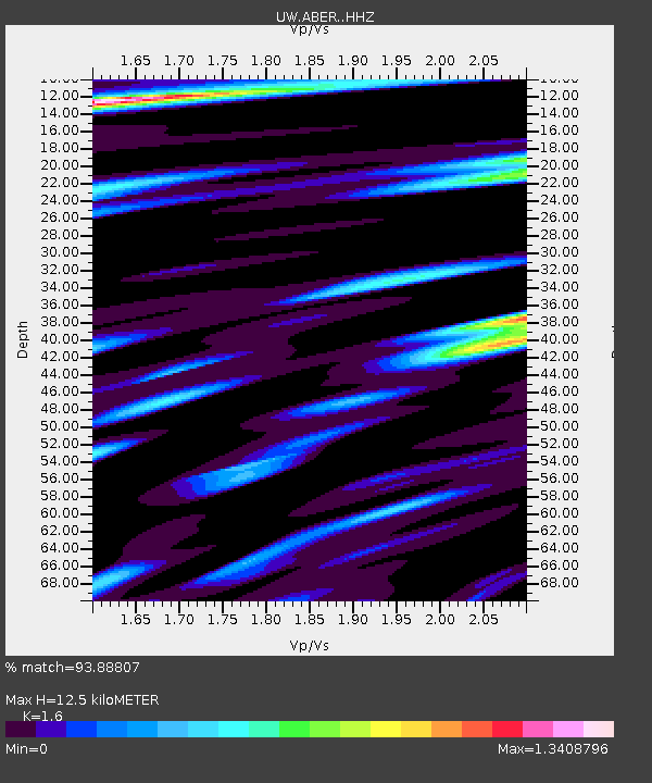
| Estimated Moho Depth: |
12.5 km |
| Estimated Crust Vp/Vs: |
1.60 |
| Assumed Crust Vp: |
6.566 km/s |
| Estimated Crust Vs: |
4.104 km/s |
| Estimated Crust Poisson's Ratio: |
0.18 |
|
| Radial Match: |
93.88807 % |
| Radial Bump: |
400 |
| Transverse Match: |
92.33328 % |
| Transverse Bump: |
361 |
| SOD ConfigId: |
33437571 |
| Insert Time: |
2024-01-15 08:13:03.444 +0000 |
| GWidth: |
2.5 |
| Max Bumps: |
400 |
| Tol: |
0.001 |
|

Signal To Noise
| Channel | StoN | STA | LTA |
| UW:ABER: :HHZ:20240101T07:20:51.210022Z | 7.2621455 | 2.6526718E-6 | 3.6527385E-7 |
| UW:ABER: :HHN:20240101T07:20:51.210022Z | 1.3215559 | 8.3114486E-7 | 6.2891394E-7 |
| UW:ABER: :HHE:20240101T07:20:51.210022Z | 1.9963344 | 1.3213507E-6 | 6.6188846E-7 |
| Arrivals |
| Ps | 1.2 SECOND |
| PpPs | 4.7 SECOND |
| PsPs/PpSs | 5.9 SECOND |


