You are here: Home > Network List > UW - Pacific Northwest Regional Seismic Network Stations List
> Station ABER Abernathy Mountain, Cowlitz County, WA, USA > Earthquake Result Viewer
ABER Abernathy Mountain, Cowlitz County, WA, USA - Earthquake Result Viewer
| Earthquake location: |
Fox Islands, Aleutian Islands |
| Earthquake latitude/longitude: |
52.2/-170.9 |
| Earthquake time(UTC): |
2024/05/19 (140) 09:35:24 GMT |
| Earthquake Depth: |
28 km |
| Earthquake Magnitude: |
6.0 mww |
| Earthquake Catalog/Contributor: |
NEIC PDE/us |
|
| Network: |
UW Pacific Northwest Regional Seismic Network |
| Station: |
ABER Abernathy Mountain, Cowlitz County, WA, USA |
| Lat/Lon: |
46.34 N/123.10 W |
| Elevation: |
786 m |
|
| Distance: |
31.2 deg |
| Az: |
81.41 deg |
| Baz: |
298.444 deg |
| Ray Param: |
0.07911286 |
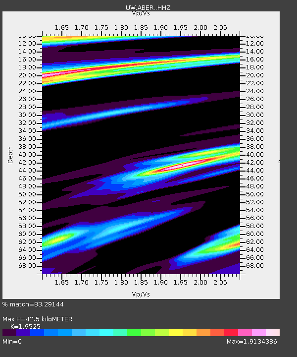
| Estimated Moho Depth: |
42.5 km |
| Estimated Crust Vp/Vs: |
1.95 |
| Assumed Crust Vp: |
6.566 km/s |
| Estimated Crust Vs: |
3.363 km/s |
| Estimated Crust Poisson's Ratio: |
0.32 |
|
| Radial Match: |
83.29144 % |
| Radial Bump: |
346 |
| Transverse Match: |
63.98534 % |
| Transverse Bump: |
400 |
| SOD ConfigId: |
35001331 |
| Insert Time: |
2024-06-02 10:12:36.900 +0000 |
| GWidth: |
2.5 |
| Max Bumps: |
400 |
| Tol: |
0.001 |
|

Signal To Noise
| Channel | StoN | STA | LTA |
| UW:ABER: :HHZ:20240519T09:41:11.770015Z | 6.0304294 | 9.176802E-7 | 1.5217495E-7 |
| UW:ABER: :HHN:20240519T09:41:11.770015Z | 2.2714608 | 5.1837736E-7 | 2.2821321E-7 |
| UW:ABER: :HHE:20240519T09:41:11.770015Z | 1.2462038 | 3.135148E-7 | 2.5157584E-7 |
| Arrivals |
| Ps | 6.7 SECOND |
| PpPs | 18 SECOND |
| PsPs/PpSs | 24 SECOND |


