You are here: Home > Network List > WY - Yellowstone Wyoming Seismic Network Stations List
> Station YHH Holmes Hill, YNP, WY, USA > Earthquake Result Viewer
YHH Holmes Hill, YNP, WY, USA - Earthquake Result Viewer
| Earthquake location: |
Tonga Islands |
| Earthquake latitude/longitude: |
-19.3/-175.5 |
| Earthquake time(UTC): |
2015/05/20 (140) 00:30:51 GMT |
| Earthquake Depth: |
180 km |
| Earthquake Magnitude: |
6.0 MWP |
| Earthquake Catalog/Contributor: |
NEIC PDE/NEIC COMCAT |
|
| Network: |
WY Yellowstone Wyoming Seismic Network |
| Station: |
YHH Holmes Hill, YNP, WY, USA |
| Lat/Lon: |
44.79 N/110.85 W |
| Elevation: |
2717 m |
|
| Distance: |
86.7 deg |
| Az: |
40.119 deg |
| Baz: |
238.724 deg |
| Ray Param: |
0.043446187 |
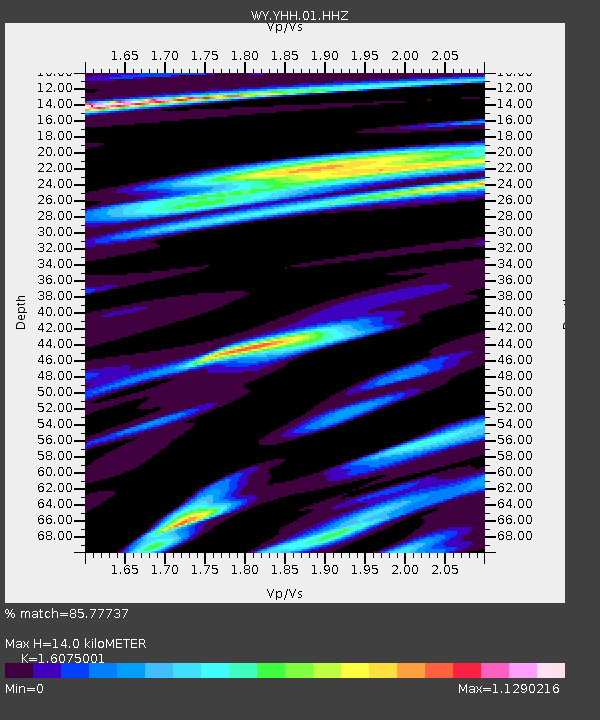
| Estimated Moho Depth: |
14.0 km |
| Estimated Crust Vp/Vs: |
1.61 |
| Assumed Crust Vp: |
6.35 km/s |
| Estimated Crust Vs: |
3.95 km/s |
| Estimated Crust Poisson's Ratio: |
0.18 |
|
| Radial Match: |
85.77737 % |
| Radial Bump: |
400 |
| Transverse Match: |
81.956764 % |
| Transverse Bump: |
400 |
| SOD ConfigId: |
976571 |
| Insert Time: |
2015-06-03 00:40:04.014 +0000 |
| GWidth: |
2.5 |
| Max Bumps: |
400 |
| Tol: |
0.001 |
|
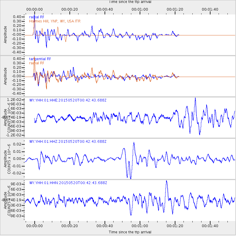
Signal To Noise
| Channel | StoN | STA | LTA |
| WY:YHH:01:HHZ:20150520T00:42:43.688Z | 2.945706 | 6.160575E-9 | 2.0913749E-9 |
| WY:YHH:01:HHN:20150520T00:42:43.688Z | 1.8939867 | 1.8149031E-9 | 9.582449E-10 |
| WY:YHH:01:HHE:20150520T00:42:43.688Z | 1.296907 | 1.8910205E-9 | 1.4581003E-9 |
| Arrivals |
| Ps | 1.4 SECOND |
| PpPs | 5.6 SECOND |
| PsPs/PpSs | 7.0 SECOND |


