You are here: Home > Network List > 7A - Mid-Atlantic Geophysical Integrative Collaboration Stations List
> Station WINE Liberty, Virginia USA > Earthquake Result Viewer
WINE Liberty, Virginia USA - Earthquake Result Viewer
| Earthquake location: |
Near Coast Of Central Chile |
| Earthquake latitude/longitude: |
-31.5/-71.2 |
| Earthquake time(UTC): |
2015/09/22 (265) 07:12:59 GMT |
| Earthquake Depth: |
54 km |
| Earthquake Magnitude: |
6.1 MWB |
| Earthquake Catalog/Contributor: |
NEIC PDE/NEIC COMCAT |
|
| Network: |
7A Mid-Atlantic Geophysical Integrative Collaboration |
| Station: |
WINE Liberty, Virginia USA |
| Lat/Lon: |
38.16 N/78.32 W |
| Elevation: |
119 m |
|
| Distance: |
69.6 deg |
| Az: |
354.013 deg |
| Baz: |
173.509 deg |
| Ray Param: |
0.05542699 |
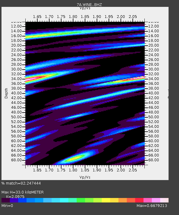
| Estimated Moho Depth: |
33.0 km |
| Estimated Crust Vp/Vs: |
2.10 |
| Assumed Crust Vp: |
6.159 km/s |
| Estimated Crust Vs: |
2.936 km/s |
| Estimated Crust Poisson's Ratio: |
0.35 |
|
| Radial Match: |
82.247444 % |
| Radial Bump: |
400 |
| Transverse Match: |
65.05437 % |
| Transverse Bump: |
400 |
| SOD ConfigId: |
7422571 |
| Insert Time: |
2019-04-20 23:55:16.319 +0000 |
| GWidth: |
2.5 |
| Max Bumps: |
400 |
| Tol: |
0.001 |
|

Signal To Noise
| Channel | StoN | STA | LTA |
| 7A:WINE: :BHZ:20150922T07:23:31.915015Z | 8.550249 | 1.693681E-6 | 1.9808557E-7 |
| 7A:WINE: :BHN:20150922T07:23:31.915015Z | 5.29295 | 7.900699E-7 | 1.4926835E-7 |
| 7A:WINE: :BHE:20150922T07:23:31.915015Z | 0.91844624 | 1.5448997E-7 | 1.6820796E-7 |
| Arrivals |
| Ps | 6.1 SECOND |
| PpPs | 16 SECOND |
| PsPs/PpSs | 22 SECOND |


