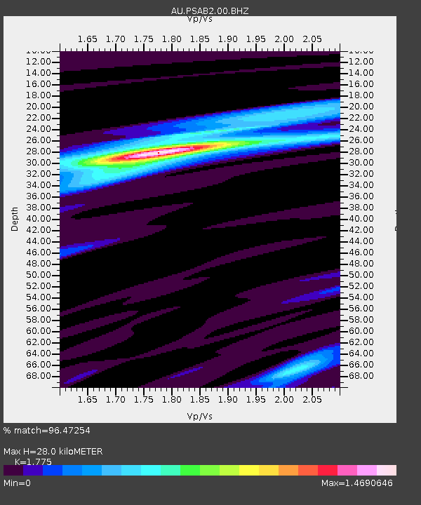
PSAB2 Pilbara Seismic Array Element B2 - Earthquake Result Viewer

Earthquake location: Santa Cruz Islands Region
Earthquake latitude/longitude: -10.9/164.2
Earthquake time(UTC): 2015/05/20 (140) 22:48:53 GMT
Earthquake Depth: 12 km
Earthquake Magnitude: 6.8 MWW, 6.7 MWB, 6.8 MWC, 6.9 MI
Earthquake Catalog/Contributor: NEIC PDE/NEIC COMCAT
Network: AU Australian Seismological Centre
Station: PSAB2 Pilbara Seismic Array Element B2
Lat/Lon: 21.55 S/119.86 E
Elevation: 302 m
Distance: 43.7 deg
Az: 250.226 deg
Baz: 83.177 deg
Ray Param: 0.07237803
Estimated Moho Depth: 28.0 km
Estimated Crust Vp/Vs: 1.77
Assumed Crust Vp: 6.464 km/s
Estimated Crust Vs: 3.641 km/s
Estimated Crust Poisson's Ratio: 0.27
Radial Match: 96.47254 %
Radial Bump: 163
Transverse Match: 83.50948 %
Transverse Bump: 400
SOD ConfigId: 976571
Insert Time: 2015-06-03 22:55:38.887 +0000
GWidth: 2.5
Max Bumps: 400
Tol: 0.001

Signal To Noise

ChannelStoNSTALTA
AU:PSAB2:00:BHZ:20150520T22:56:26.893994Z3.6706091.5477348E-64.2165613E-7
AU:PSAB2:00:BH1:20150520T22:56:26.893994Z2.82863168.7096544E-73.079105E-7
AU:PSAB2:00:BH2:20150520T22:56:26.893994Z1.87399965.798329E-73.094093E-7
Arrivals
Ps3.6 SECOND
PpPs11 SECOND
PsPs/PpSs15 SECOND