You are here: Home > Network List > PB - Plate Boundary Observatory Borehole Seismic Network Stations List
> Station B082 pathfi082bcs2006, Anza, CA, USA > Earthquake Result Viewer
B082 pathfi082bcs2006, Anza, CA, USA - Earthquake Result Viewer
| Earthquake location: |
Near Coast Of Central Chile |
| Earthquake latitude/longitude: |
-31.5/-71.2 |
| Earthquake time(UTC): |
2015/09/22 (265) 07:12:59 GMT |
| Earthquake Depth: |
54 km |
| Earthquake Magnitude: |
6.1 MWB |
| Earthquake Catalog/Contributor: |
NEIC PDE/NEIC COMCAT |
|
| Network: |
PB Plate Boundary Observatory Borehole Seismic Network |
| Station: |
B082 pathfi082bcs2006, Anza, CA, USA |
| Lat/Lon: |
33.60 N/116.60 W |
| Elevation: |
1375 m |
|
| Distance: |
77.6 deg |
| Az: |
322.522 deg |
| Baz: |
141.476 deg |
| Ray Param: |
0.0500998 |
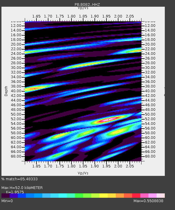
| Estimated Moho Depth: |
52.0 km |
| Estimated Crust Vp/Vs: |
1.96 |
| Assumed Crust Vp: |
6.264 km/s |
| Estimated Crust Vs: |
3.2 km/s |
| Estimated Crust Poisson's Ratio: |
0.32 |
|
| Radial Match: |
85.48333 % |
| Radial Bump: |
400 |
| Transverse Match: |
87.08993 % |
| Transverse Bump: |
400 |
| SOD ConfigId: |
7422571 |
| Insert Time: |
2019-04-21 00:02:33.400 +0000 |
| GWidth: |
2.5 |
| Max Bumps: |
400 |
| Tol: |
0.001 |
|

Signal To Noise
| Channel | StoN | STA | LTA |
| PB:B082: :HHZ:20150922T07:24:18.678992Z | 25.571215 | 4.968595E-8 | 1.9430422E-9 |
| PB:B082: :HH1:20150922T07:24:18.678992Z | 3.9335823 | 7.6773405E-9 | 1.9517425E-9 |
| PB:B082: :HH2:20150922T07:24:18.678992Z | 7.732137 | 1.17167085E-8 | 1.515326E-9 |
| Arrivals |
| Ps | 8.2 SECOND |
| PpPs | 24 SECOND |
| PsPs/PpSs | 32 SECOND |


