You are here: Home > Network List > PR - Puerto Rico Seismic Network (PRSN) & Puerto Rico Strong Motion Program (PRSMP) Stations List
> Station MLPR Magueyes > Earthquake Result Viewer
MLPR Magueyes - Earthquake Result Viewer
| Earthquake location: |
Near Coast Of Central Chile |
| Earthquake latitude/longitude: |
-31.5/-71.2 |
| Earthquake time(UTC): |
2015/09/22 (265) 07:12:59 GMT |
| Earthquake Depth: |
54 km |
| Earthquake Magnitude: |
6.1 MWB |
| Earthquake Catalog/Contributor: |
NEIC PDE/NEIC COMCAT |
|
| Network: |
PR Puerto Rico Seismic Network (PRSN) & Puerto Rico Strong Motion Program (PRSMP) |
| Station: |
MLPR Magueyes |
| Lat/Lon: |
17.97 N/67.04 W |
| Elevation: |
0.0 m |
|
| Distance: |
49.3 deg |
| Az: |
5.213 deg |
| Baz: |
184.678 deg |
| Ray Param: |
0.0686294 |
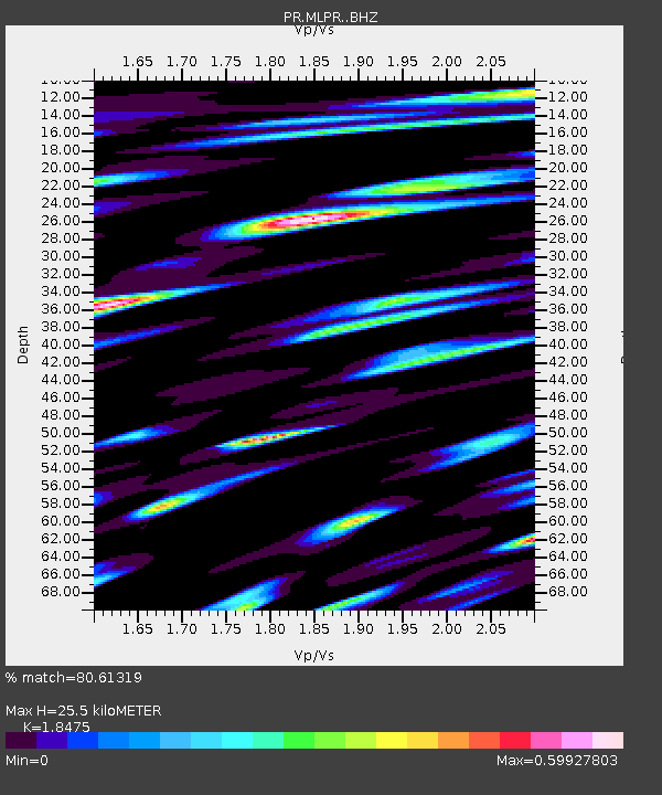
| Estimated Moho Depth: |
25.5 km |
| Estimated Crust Vp/Vs: |
1.85 |
| Assumed Crust Vp: |
4.082 km/s |
| Estimated Crust Vs: |
2.21 km/s |
| Estimated Crust Poisson's Ratio: |
0.29 |
|
| Radial Match: |
80.61319 % |
| Radial Bump: |
400 |
| Transverse Match: |
69.65322 % |
| Transverse Bump: |
400 |
| SOD ConfigId: |
7422571 |
| Insert Time: |
2019-04-21 00:02:59.356 +0000 |
| GWidth: |
2.5 |
| Max Bumps: |
400 |
| Tol: |
0.001 |
|

Signal To Noise
| Channel | StoN | STA | LTA |
| PR:MLPR: :BHZ:20150922T07:21:12.540015Z | 43.789776 | 3.6278882E-6 | 8.284783E-8 |
| PR:MLPR: :BHN:20150922T07:21:12.540015Z | 11.715989 | 1.401545E-6 | 1.1962669E-7 |
| PR:MLPR: :BHE:20150922T07:21:12.540015Z | 3.0784085 | 6.378817E-7 | 2.0721154E-7 |
| Arrivals |
| Ps | 5.4 SECOND |
| PpPs | 17 SECOND |
| PsPs/PpSs | 23 SECOND |


