You are here: Home > Network List > TA - USArray Transportable Network (new EarthScope stations) Stations List
> Station 833A Chaparral WMA, Artesia Wells, TX, USA > Earthquake Result Viewer
833A Chaparral WMA, Artesia Wells, TX, USA - Earthquake Result Viewer
| Earthquake location: |
Near Coast Of Central Chile |
| Earthquake latitude/longitude: |
-31.5/-71.2 |
| Earthquake time(UTC): |
2015/09/22 (265) 07:12:59 GMT |
| Earthquake Depth: |
54 km |
| Earthquake Magnitude: |
6.1 MWB |
| Earthquake Catalog/Contributor: |
NEIC PDE/NEIC COMCAT |
|
| Network: |
TA USArray Transportable Network (new EarthScope stations) |
| Station: |
833A Chaparral WMA, Artesia Wells, TX, USA |
| Lat/Lon: |
28.32 N/99.39 W |
| Elevation: |
171 m |
|
| Distance: |
65.3 deg |
| Az: |
332.697 deg |
| Baz: |
153.606 deg |
| Ray Param: |
0.058272935 |
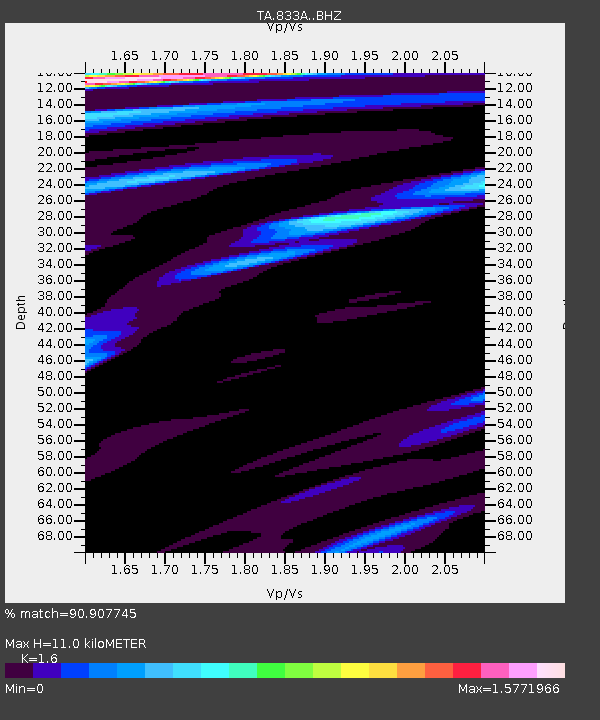
| Estimated Moho Depth: |
11.0 km |
| Estimated Crust Vp/Vs: |
1.60 |
| Assumed Crust Vp: |
6.347 km/s |
| Estimated Crust Vs: |
3.967 km/s |
| Estimated Crust Poisson's Ratio: |
0.18 |
|
| Radial Match: |
90.907745 % |
| Radial Bump: |
400 |
| Transverse Match: |
79.81632 % |
| Transverse Bump: |
400 |
| SOD ConfigId: |
7422571 |
| Insert Time: |
2019-04-21 00:03:31.102 +0000 |
| GWidth: |
2.5 |
| Max Bumps: |
400 |
| Tol: |
0.001 |
|

Signal To Noise
| Channel | StoN | STA | LTA |
| TA:833A: :BHZ:20150922T07:23:04.449988Z | 18.631893 | 1.9254667E-6 | 1.03342515E-7 |
| TA:833A: :BHN:20150922T07:23:04.449988Z | 3.58191 | 4.2086853E-7 | 1.1749836E-7 |
| TA:833A: :BHE:20150922T07:23:04.449988Z | 2.5561848 | 3.5445976E-7 | 1.3866752E-7 |
| Arrivals |
| Ps | 1.1 SECOND |
| PpPs | 4.3 SECOND |
| PsPs/PpSs | 5.4 SECOND |


