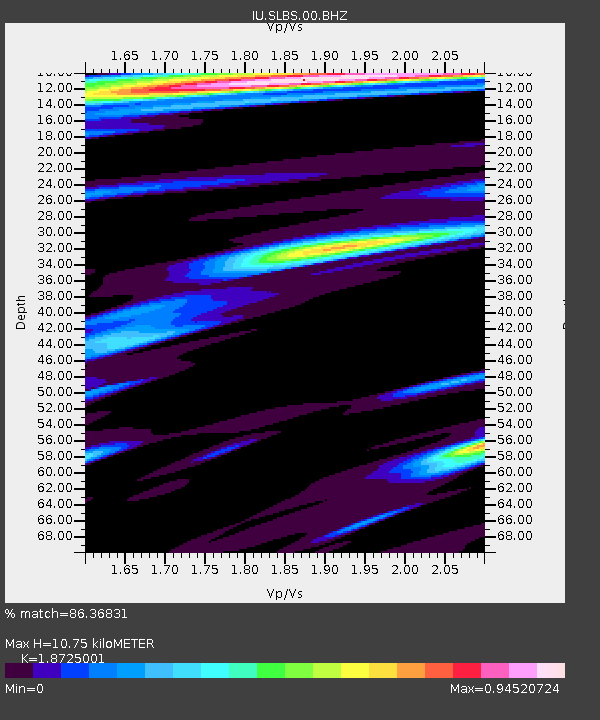
SLBS Sierra la Laguna Baja California Sur, Mexico - Earthquake Result Viewer
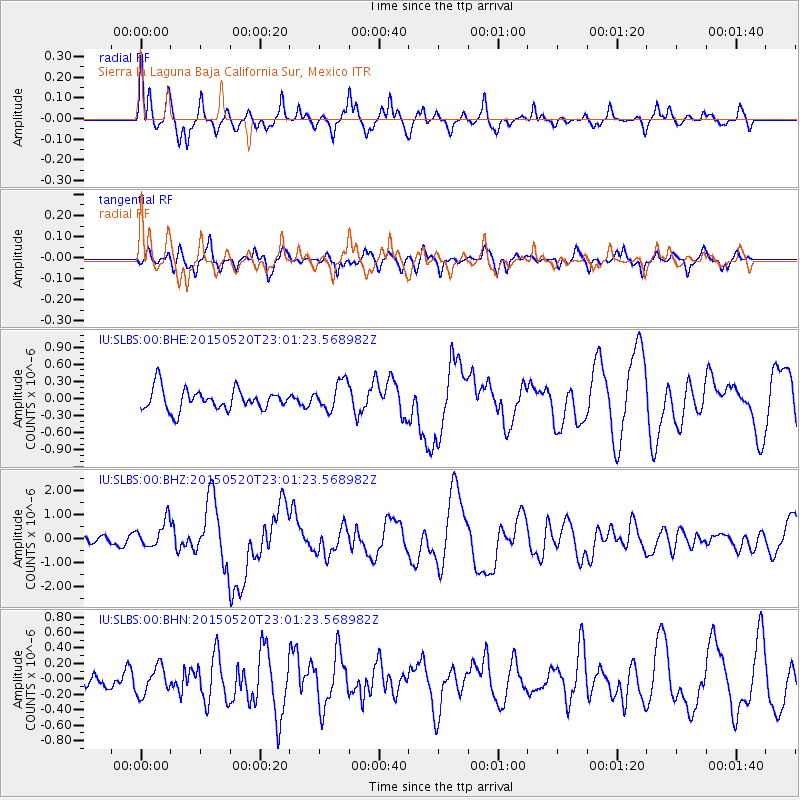
Earthquake location: Santa Cruz Islands Region
Earthquake latitude/longitude: -10.9/164.2
Earthquake time(UTC): 2015/05/20 (140) 22:48:53 GMT
Earthquake Depth: 12 km
Earthquake Magnitude: 6.8 MWW, 6.7 MWB, 6.8 MWC, 6.9 MI
Earthquake Catalog/Contributor: NEIC PDE/NEIC COMCAT
Network: IU Global Seismograph Network (GSN - IRIS/USGS)
Station: SLBS Sierra la Laguna Baja California Sur, Mexico
Lat/Lon: 23.69 N/109.94 W
Elevation: 825 m
Distance: 90.6 deg
Az: 66.128 deg
Baz: 258.455 deg
Ray Param: 0.041661166
Estimated Moho Depth: 10.75 km
Estimated Crust Vp/Vs: 1.87
Assumed Crust Vp: 6.183 km/s
Estimated Crust Vs: 3.302 km/s
Estimated Crust Poisson's Ratio: 0.30
Radial Match: 86.36831 %
Radial Bump: 400
Transverse Match: 69.79098 %
Transverse Bump: 400
SOD ConfigId: 976571
Insert Time: 2015-06-03 22:58:17.305 +0000
GWidth: 2.5
Max Bumps: 400
Tol: 0.001

Signal To Noise

ChannelStoNSTALTA
IU:SLBS:00:BHZ:20150520T23:01:23.568982Z2.82908875.6180824E-71.9858275E-7
IU:SLBS:00:BHN:20150520T23:01:23.568982Z1.01550151.8211159E-71.7933168E-7
IU:SLBS:00:BHE:20150520T23:01:23.568982Z1.36095022.5118075E-71.8456277E-7
Arrivals
Ps1.5 SECOND
PpPs4.9 SECOND
PsPs/PpSs6.4 SECOND