You are here: Home > Network List > IU - Global Seismograph Network (GSN - IRIS/USGS) Stations List
> Station OTAV Otavalu, Ecuador > Earthquake Result Viewer
OTAV Otavalu, Ecuador - Earthquake Result Viewer
| Earthquake location: |
Tonga Islands |
| Earthquake latitude/longitude: |
-17.2/-173.9 |
| Earthquake time(UTC): |
2000/09/26 (270) 06:17:52 GMT |
| Earthquake Depth: |
56 km |
| Earthquake Magnitude: |
6.1 MB, 6.1 MS, 6.4 MW, 6.1 ME |
| Earthquake Catalog/Contributor: |
WHDF/NEIC |
|
| Network: |
IU Global Seismograph Network (GSN - IRIS/USGS) |
| Station: |
OTAV Otavalu, Ecuador |
| Lat/Lon: |
0.24 N/78.45 W |
| Elevation: |
3507 m |
|
| Distance: |
95.3 deg |
| Az: |
91.385 deg |
| Baz: |
252.877 deg |
| Ray Param: |
0.040784515 |
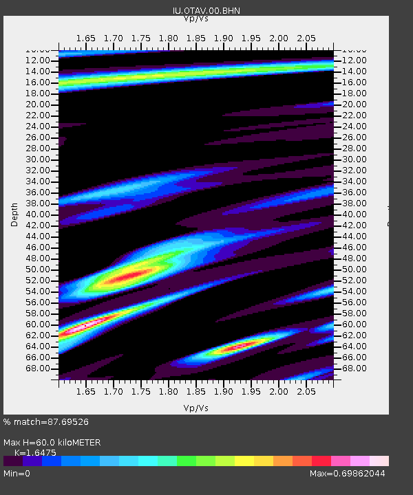
| Estimated Moho Depth: |
60.0 km |
| Estimated Crust Vp/Vs: |
1.65 |
| Assumed Crust Vp: |
6.472 km/s |
| Estimated Crust Vs: |
3.928 km/s |
| Estimated Crust Poisson's Ratio: |
0.21 |
|
| Radial Match: |
87.69526 % |
| Radial Bump: |
400 |
| Transverse Match: |
85.72484 % |
| Transverse Bump: |
400 |
| SOD ConfigId: |
3744 |
| Insert Time: |
2010-03-04 20:33:27.380 +0000 |
| GWidth: |
2.5 |
| Max Bumps: |
400 |
| Tol: |
0.001 |
|
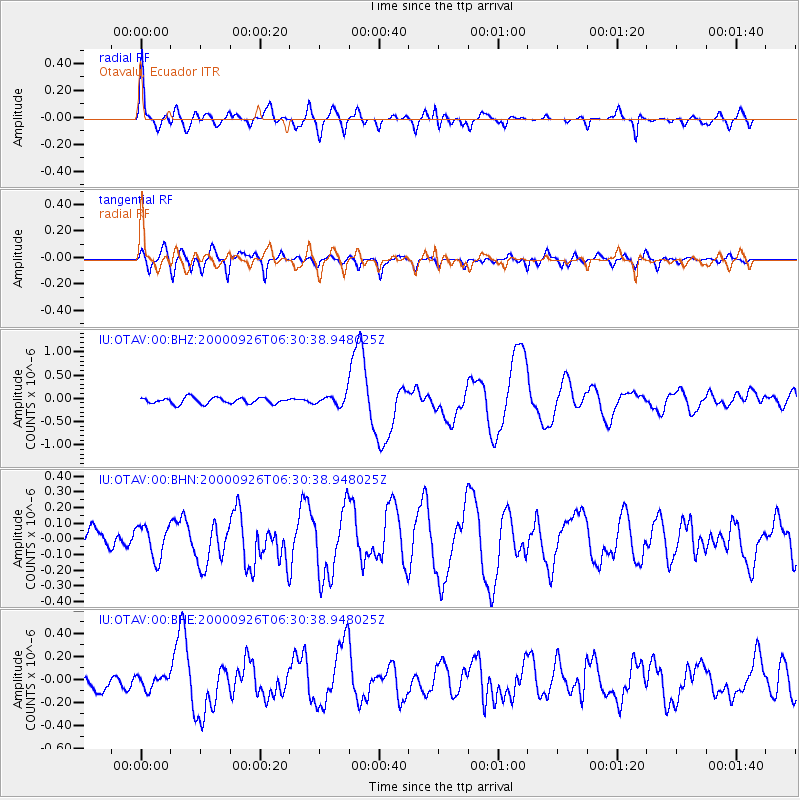
Signal To Noise
| Channel | StoN | STA | LTA |
| IU:OTAV:00:BHN:20000926T06:30:38.948025Z | 2.1185696 | 1.0524669E-7 | 4.9678185E-8 |
| IU:OTAV:00:BHE:20000926T06:30:38.948025Z | 1.0874708 | 5.5672878E-8 | 5.1194824E-8 |
| IU:OTAV:00:BHZ:20000926T06:30:38.948025Z | 1.6887612 | 1.1027811E-7 | 6.530118E-8 |
| Arrivals |
| Ps | 6.1 SECOND |
| PpPs | 24 SECOND |
| PsPs/PpSs | 30 SECOND |


