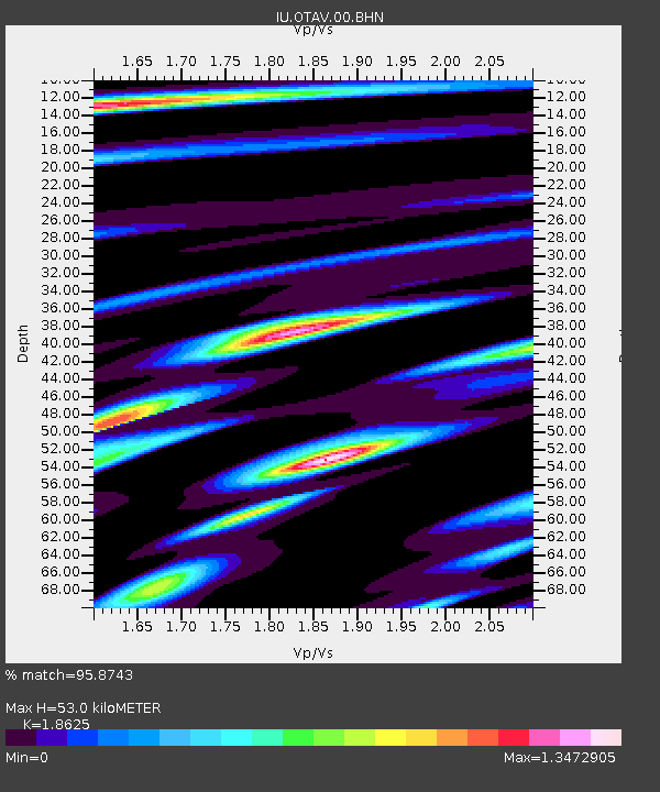
OTAV Otavalu, Ecuador - Earthquake Result Viewer
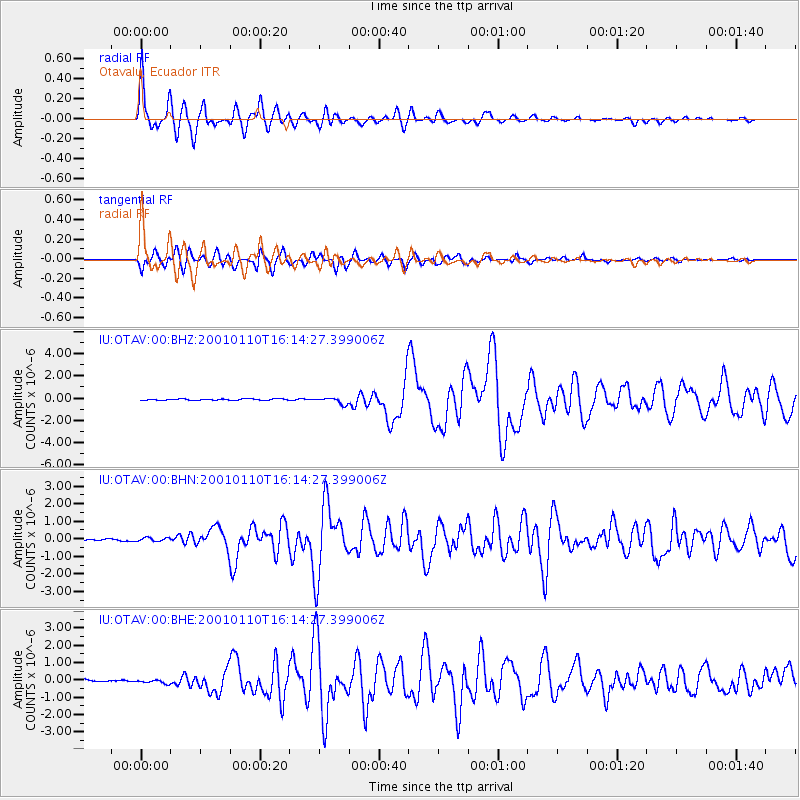
Earthquake location: Kodiak Island Region, Alaska
Earthquake latitude/longitude: 57.1/-153.2
Earthquake time(UTC): 2001/01/10 (010) 16:02:44 GMT
Earthquake Depth: 33 km
Earthquake Magnitude: 6.2 MB, 6.8 MS, 7.1 MW, 6.8 ML
Earthquake Catalog/Contributor: WHDF/NEIC
Network: IU Global Seismograph Network (GSN - IRIS/USGS)
Station: OTAV Otavalu, Ecuador
Lat/Lon: 0.24 N/78.45 W
Elevation: 3507 m
Distance: 81.5 deg
Az: 102.73 deg
Baz: 327.815 deg
Ray Param: 0.047464594
Estimated Moho Depth: 53.0 km
Estimated Crust Vp/Vs: 1.86
Assumed Crust Vp: 6.472 km/s
Estimated Crust Vs: 3.475 km/s
Estimated Crust Poisson's Ratio: 0.30
Radial Match: 95.8743 %
Radial Bump: 400
Transverse Match: 92.79259 %
Transverse Bump: 400
SOD ConfigId: 3744
Insert Time: 2010-03-04 20:33:32.502 +0000
GWidth: 2.5
Max Bumps: 400
Tol: 0.001

Signal To Noise

ChannelStoNSTALTA
IU:OTAV:00:BHN:20010110T16:14:27.399006Z1.24065591.0275826E-78.282575E-8
IU:OTAV:00:BHE:20010110T16:14:27.399006Z1.27821171.065322E-78.3344716E-8
IU:OTAV:00:BHZ:20010110T16:14:27.399006Z4.1300572.9440778E-77.128419E-8
Arrivals
Ps7.3 SECOND
PpPs23 SECOND
PsPs/PpSs30 SECOND