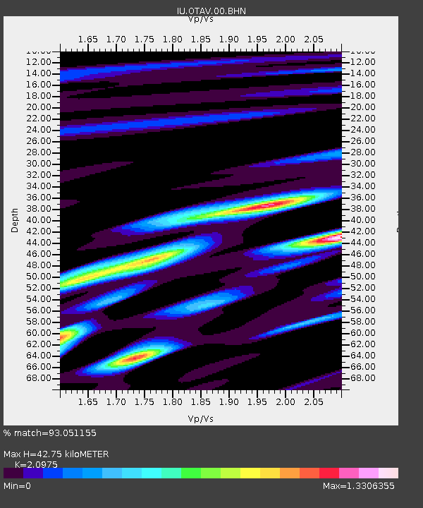
OTAV Otavalu, Ecuador - Earthquake Result Viewer
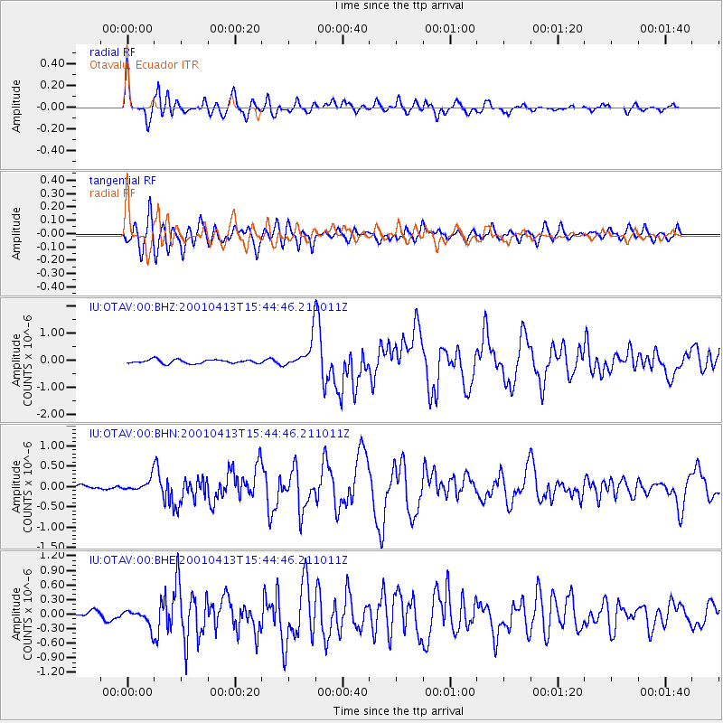
Earthquake location: South Sandwich Islands Region
Earthquake latitude/longitude: -59.7/-25.6
Earthquake time(UTC): 2001/04/13 (103) 15:33:53 GMT
Earthquake Depth: 26 km
Earthquake Magnitude: 5.3 MB, 6.0 MS, 6.2 MW, 6.2 MW
Earthquake Catalog/Contributor: WHDF/NEIC
Network: IU Global Seismograph Network (GSN - IRIS/USGS)
Station: OTAV Otavalu, Ecuador
Lat/Lon: 0.24 N/78.45 W
Elevation: 3507 m
Distance: 72.4 deg
Az: 303.243 deg
Baz: 154.926 deg
Ray Param: 0.05365126
Estimated Moho Depth: 42.75 km
Estimated Crust Vp/Vs: 2.10
Assumed Crust Vp: 6.472 km/s
Estimated Crust Vs: 3.086 km/s
Estimated Crust Poisson's Ratio: 0.35
Radial Match: 93.051155 %
Radial Bump: 400
Transverse Match: 80.9853 %
Transverse Bump: 400
SOD ConfigId: 4714
Insert Time: 2010-03-04 20:33:34.082 +0000
GWidth: 2.5
Max Bumps: 400
Tol: 0.001

Signal To Noise

ChannelStoNSTALTA
IU:OTAV:00:BHN:20010413T15:44:46.211011Z1.78881591.5966442E-78.925705E-8
IU:OTAV:00:BHE:20010413T15:44:46.211011Z2.8038221.7960465E-76.405708E-8
IU:OTAV:00:BHZ:20010413T15:44:46.211011Z7.87770655.5008053E-76.98275E-8
Arrivals
Ps7.5 SECOND
PpPs20 SECOND
PsPs/PpSs27 SECOND