You are here: Home > Network List > IU - Global Seismograph Network (GSN - IRIS/USGS) Stations List
> Station OTAV Otavalu, Ecuador > Earthquake Result Viewer
OTAV Otavalu, Ecuador - Earthquake Result Viewer
| Earthquake location: |
South Sandwich Islands Region |
| Earthquake latitude/longitude: |
-55.9/-29.0 |
| Earthquake time(UTC): |
2002/02/10 (041) 01:47:06 GMT |
| Earthquake Depth: |
193 km |
| Earthquake Magnitude: |
5.7 MB, 6.0 MW, 5.9 MW |
| Earthquake Catalog/Contributor: |
WHDF/NEIC |
|
| Network: |
IU Global Seismograph Network (GSN - IRIS/USGS) |
| Station: |
OTAV Otavalu, Ecuador |
| Lat/Lon: |
0.24 N/78.45 W |
| Elevation: |
3507 m |
|
| Distance: |
68.7 deg |
| Az: |
305.383 deg |
| Baz: |
152.674 deg |
| Ray Param: |
0.05556173 |
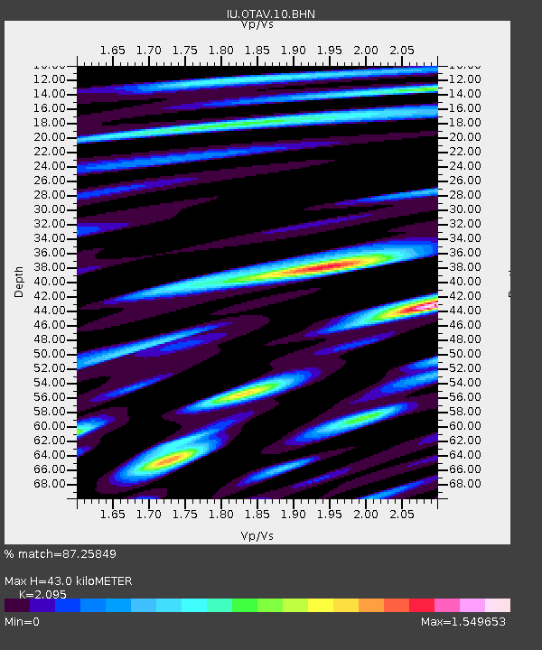
| Estimated Moho Depth: |
43.0 km |
| Estimated Crust Vp/Vs: |
2.10 |
| Assumed Crust Vp: |
6.472 km/s |
| Estimated Crust Vs: |
3.089 km/s |
| Estimated Crust Poisson's Ratio: |
0.35 |
|
| Radial Match: |
87.25849 % |
| Radial Bump: |
400 |
| Transverse Match: |
85.14928 % |
| Transverse Bump: |
400 |
| SOD ConfigId: |
4714 |
| Insert Time: |
2010-03-04 20:33:37.168 +0000 |
| GWidth: |
2.5 |
| Max Bumps: |
400 |
| Tol: |
0.001 |
|
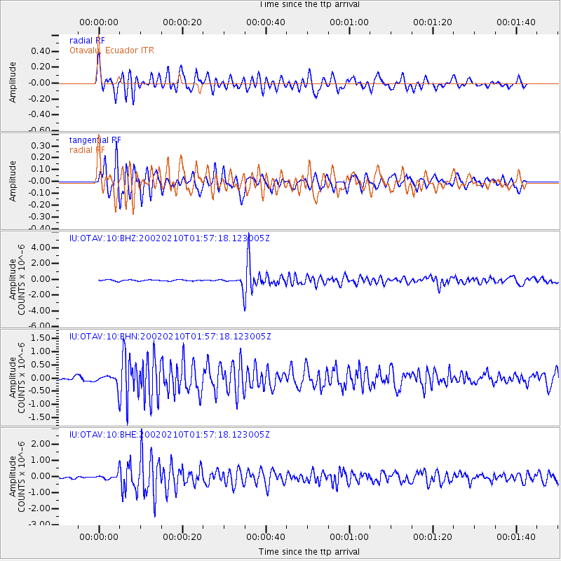
Signal To Noise
| Channel | StoN | STA | LTA |
| IU:OTAV:10:BHN:20020210T01:57:18.123005Z | 3.718769 | 2.564415E-7 | 6.8958705E-8 |
| IU:OTAV:10:BHE:20020210T01:57:18.123005Z | 2.7236123 | 2.0621664E-7 | 7.571439E-8 |
| IU:OTAV:10:BHZ:20020210T01:57:18.123005Z | 10.001079 | 7.509454E-7 | 7.508644E-8 |
| Arrivals |
| Ps | 7.5 SECOND |
| PpPs | 20 SECOND |
| PsPs/PpSs | 27 SECOND |


