You are here: Home > Network List > IW - Intermountain West Stations List
> Station DLMT Dillon, Montana, USA > Earthquake Result Viewer
DLMT Dillon, Montana, USA - Earthquake Result Viewer
| Earthquake location: |
Santa Cruz Islands Region |
| Earthquake latitude/longitude: |
-10.9/164.2 |
| Earthquake time(UTC): |
2015/05/20 (140) 22:48:53 GMT |
| Earthquake Depth: |
12 km |
| Earthquake Magnitude: |
6.8 MWW, 6.7 MWB, 6.8 MWC, 6.9 MI |
| Earthquake Catalog/Contributor: |
NEIC PDE/NEIC COMCAT |
|
| Network: |
IW Intermountain West |
| Station: |
DLMT Dillon, Montana, USA |
| Lat/Lon: |
45.36 N/112.60 W |
| Elevation: |
1569 m |
|
| Distance: |
93.0 deg |
| Az: |
44.511 deg |
| Baz: |
257.612 deg |
| Ray Param: |
0.041354157 |
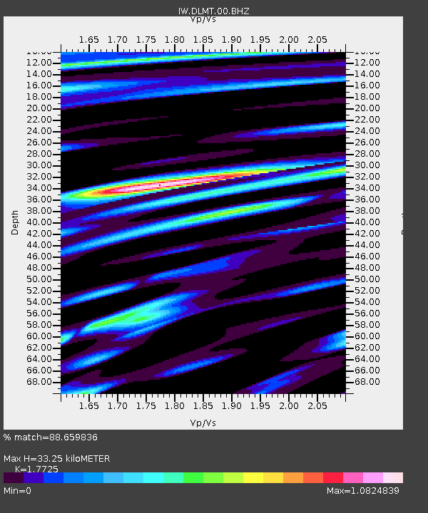
| Estimated Moho Depth: |
33.25 km |
| Estimated Crust Vp/Vs: |
1.77 |
| Assumed Crust Vp: |
6.577 km/s |
| Estimated Crust Vs: |
3.711 km/s |
| Estimated Crust Poisson's Ratio: |
0.27 |
|
| Radial Match: |
88.659836 % |
| Radial Bump: |
400 |
| Transverse Match: |
81.38455 % |
| Transverse Bump: |
400 |
| SOD ConfigId: |
976571 |
| Insert Time: |
2015-06-03 22:58:33.584 +0000 |
| GWidth: |
2.5 |
| Max Bumps: |
400 |
| Tol: |
0.001 |
|

Signal To Noise
| Channel | StoN | STA | LTA |
| IW:DLMT:00:BHZ:20150520T23:01:34.41499Z | 6.646005 | 3.3250794E-7 | 5.0031247E-8 |
| IW:DLMT:00:BH1:20150520T23:01:34.41499Z | 1.4251982 | 7.070483E-8 | 4.9610524E-8 |
| IW:DLMT:00:BH2:20150520T23:01:34.41499Z | 1.719029 | 1.1151222E-7 | 6.486931E-8 |
| Arrivals |
| Ps | 4.0 SECOND |
| PpPs | 14 SECOND |
| PsPs/PpSs | 18 SECOND |


