You are here: Home > Network List > IU - Global Seismograph Network (GSN - IRIS/USGS) Stations List
> Station OTAV Otavalu, Ecuador > Earthquake Result Viewer
OTAV Otavalu, Ecuador - Earthquake Result Viewer
| Earthquake location: |
South Pacific Ocean |
| Earthquake latitude/longitude: |
-20.3/-126.9 |
| Earthquake time(UTC): |
2004/07/11 (193) 23:46:12 GMT |
| Earthquake Depth: |
12 km |
| Earthquake Magnitude: |
6.1 MB, 5.9 MS, 6.1 MW, 6.1 MW |
| Earthquake Catalog/Contributor: |
WHDF/NEIC |
|
| Network: |
IU Global Seismograph Network (GSN - IRIS/USGS) |
| Station: |
OTAV Otavalu, Ecuador |
| Lat/Lon: |
0.24 N/78.45 W |
| Elevation: |
3507 m |
|
| Distance: |
51.6 deg |
| Az: |
72.784 deg |
| Baz: |
243.75 deg |
| Ray Param: |
0.06729714 |
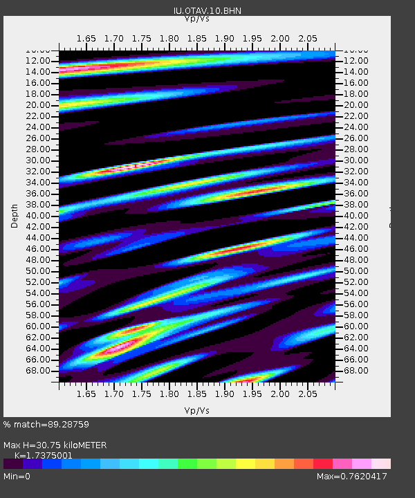
| Estimated Moho Depth: |
30.75 km |
| Estimated Crust Vp/Vs: |
1.74 |
| Assumed Crust Vp: |
6.472 km/s |
| Estimated Crust Vs: |
3.725 km/s |
| Estimated Crust Poisson's Ratio: |
0.25 |
|
| Radial Match: |
89.28759 % |
| Radial Bump: |
400 |
| Transverse Match: |
70.90608 % |
| Transverse Bump: |
400 |
| SOD ConfigId: |
2459 |
| Insert Time: |
2010-03-04 20:33:49.750 +0000 |
| GWidth: |
2.5 |
| Max Bumps: |
400 |
| Tol: |
0.001 |
|
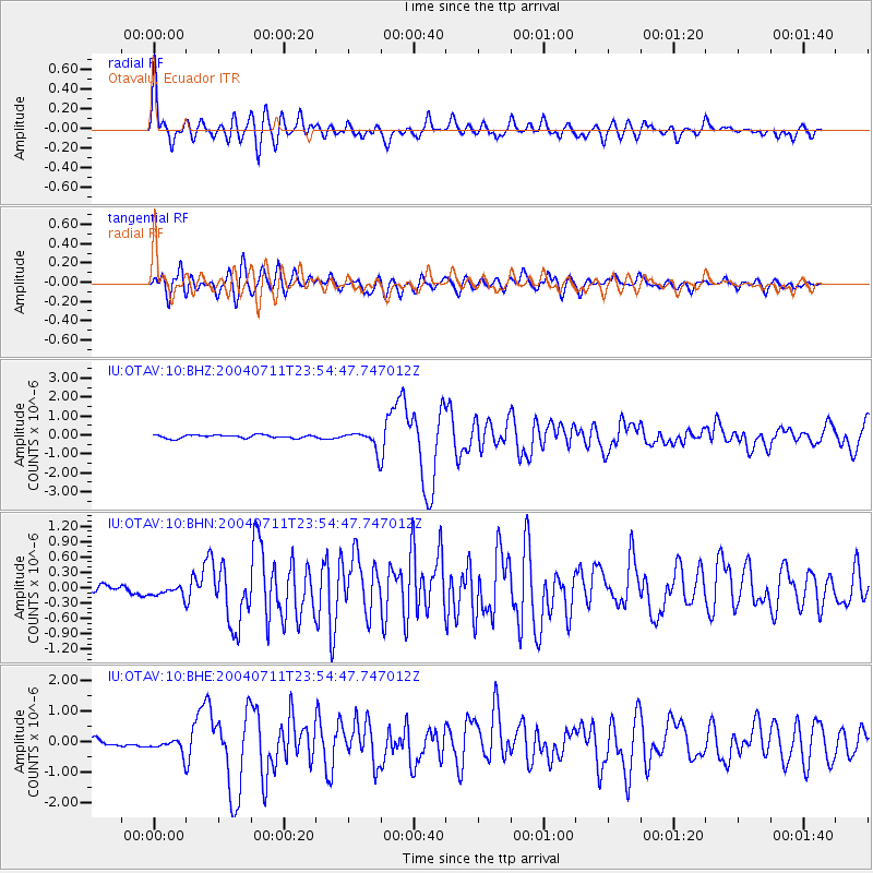
Signal To Noise
| Channel | StoN | STA | LTA |
| IU:OTAV:10:BHN:20040711T23:54:47.747012Z | 1.011752 | 1.0873293E-7 | 1.0746994E-7 |
| IU:OTAV:10:BHE:20040711T23:54:47.747012Z | 1.780332 | 2.3444812E-7 | 1.3168787E-7 |
| IU:OTAV:10:BHZ:20040711T23:54:47.747012Z | 6.107557 | 5.179886E-7 | 8.48111E-8 |
| Arrivals |
| Ps | 3.7 SECOND |
| PpPs | 12 SECOND |
| PsPs/PpSs | 16 SECOND |


