You are here: Home > Network List > UW - Pacific Northwest Regional Seismic Network Stations List
> Station HOOD Mt Hood Meadows, OR CREST BB SMO > Earthquake Result Viewer
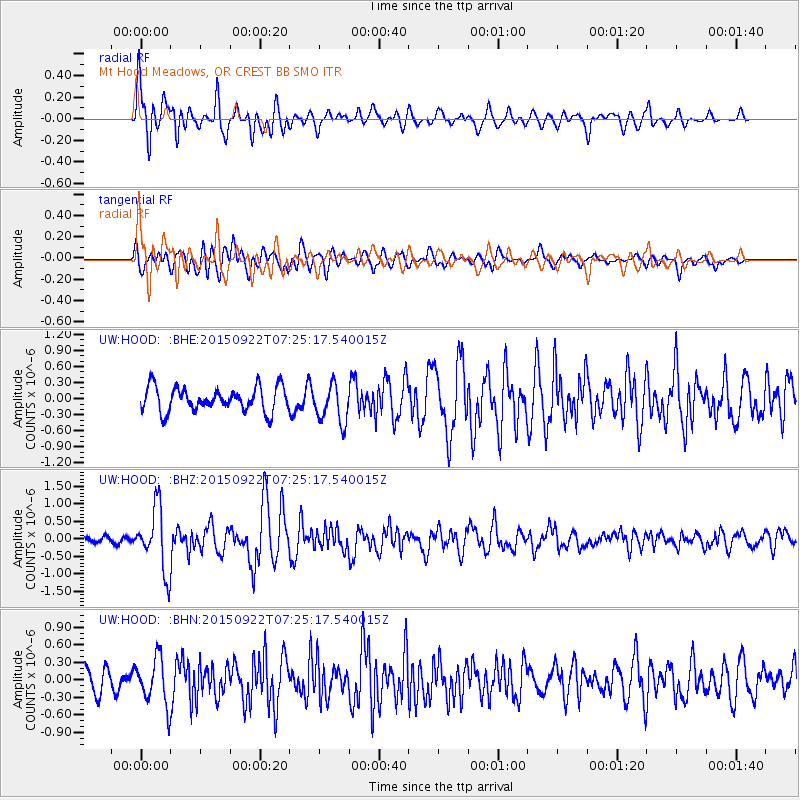
HOOD Mt Hood Meadows, OR CREST BB SMO - Earthquake Result Viewer
*The percent match for this event was below the threshold and hence no stack was calculated.
| Earthquake location: |
Near Coast Of Central Chile |
| Earthquake latitude/longitude: |
-31.5/-71.2 |
| Earthquake time(UTC): |
2015/09/22 (265) 07:12:59 GMT |
| Earthquake Depth: |
54 km |
| Earthquake Magnitude: |
6.1 MWB |
| Earthquake Catalog/Contributor: |
NEIC PDE/NEIC COMCAT |
|
| Network: |
UW Pacific Northwest Regional Seismic Network |
| Station: |
HOOD Mt Hood Meadows, OR CREST BB SMO |
| Lat/Lon: |
45.32 N/121.65 W |
| Elevation: |
1520 m |
|
| Distance: |
89.1 deg |
| Az: |
327.035 deg |
| Baz: |
138.781 deg |
| Ray Param: |
$rayparam |
*The percent match for this event was below the threshold and hence was not used in the summary stack. |
|
| Radial Match: |
78.990204 % |
| Radial Bump: |
400 |
| Transverse Match: |
64.617744 % |
| Transverse Bump: |
400 |
| SOD ConfigId: |
7422571 |
| Insert Time: |
2019-04-21 00:05:20.893 +0000 |
| GWidth: |
2.5 |
| Max Bumps: |
400 |
| Tol: |
0.001 |
|
Signal To Noise
| Channel | StoN | STA | LTA |
| UW:HOOD: :BHZ:20150922T07:25:17.540015Z | 6.9021196 | 8.8645675E-7 | 1.2843253E-7 |
| UW:HOOD: :BHN:20150922T07:25:17.540015Z | 1.971739 | 3.9806304E-7 | 2.0188423E-7 |
| UW:HOOD: :BHE:20150922T07:25:17.540015Z | 1.6734211 | 3.8405332E-7 | 2.295019E-7 |
| Arrivals |
| Ps | |
| PpPs | |
| PsPs/PpSs | |


