You are here: Home > Network List > IU - Global Seismograph Network (GSN - IRIS/USGS) Stations List
> Station OTAV Otavalu, Ecuador > Earthquake Result Viewer
OTAV Otavalu, Ecuador - Earthquake Result Viewer
| Earthquake location: |
South Sandwich Islands Region |
| Earthquake latitude/longitude: |
-58.0/-25.3 |
| Earthquake time(UTC): |
2004/09/11 (255) 21:52:38 GMT |
| Earthquake Depth: |
64 km |
| Earthquake Magnitude: |
5.8 MB, 6.1 MW, 6.1 MW |
| Earthquake Catalog/Contributor: |
WHDF/NEIC |
|
| Network: |
IU Global Seismograph Network (GSN - IRIS/USGS) |
| Station: |
OTAV Otavalu, Ecuador |
| Lat/Lon: |
0.24 N/78.45 W |
| Elevation: |
3507 m |
|
| Distance: |
71.6 deg |
| Az: |
302.534 deg |
| Baz: |
153.306 deg |
| Ray Param: |
0.054109585 |
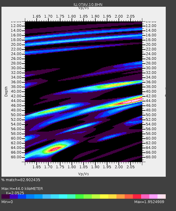
| Estimated Moho Depth: |
44.0 km |
| Estimated Crust Vp/Vs: |
2.05 |
| Assumed Crust Vp: |
6.472 km/s |
| Estimated Crust Vs: |
3.153 km/s |
| Estimated Crust Poisson's Ratio: |
0.34 |
|
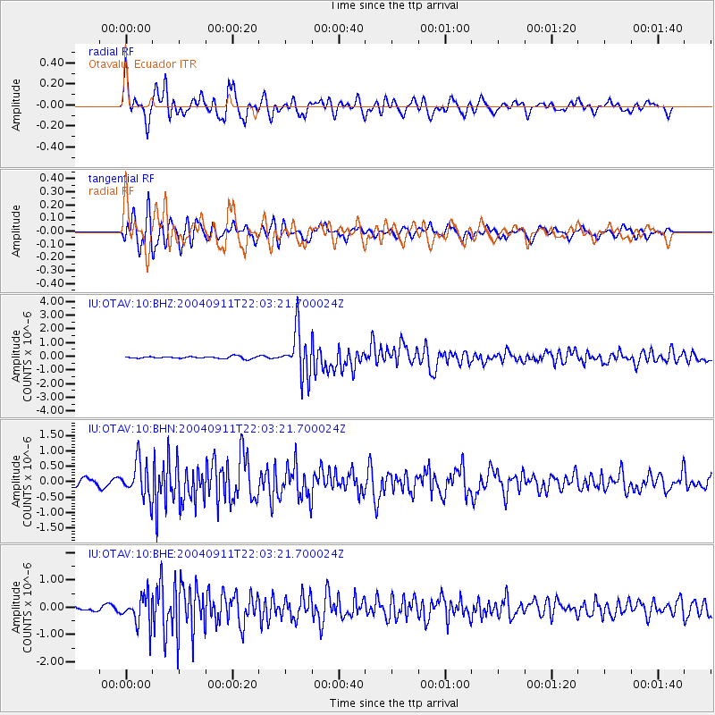
| Radial Match: |
82.902435 % |
| Radial Bump: |
400 |
| Transverse Match: |
87.14237 % |
| Transverse Bump: |
400 |
| SOD ConfigId: |
2459 |
| Insert Time: |
2010-03-04 20:34:00.650 +0000 |
| GWidth: |
2.5 |
| Max Bumps: |
400 |
| Tol: |
0.001 |
|
Signal To Noise
| Channel | StoN | STA | LTA |
| IU:OTAV:10:BHN:20040911T22:03:21.700024Z | 6.8639126 | 5.789137E-7 | 8.434165E-8 |
| IU:OTAV:10:BHE:20040911T22:03:21.700024Z | 5.1171436 | 5.472574E-7 | 1.0694588E-7 |
| IU:OTAV:10:BHZ:20040911T22:03:21.700024Z | 22.022594 | 1.6801889E-6 | 7.6293865E-8 |
| Arrivals |
| Ps | 7.4 SECOND |
| PpPs | 20 SECOND |
| PsPs/PpSs | 27 SECOND |


