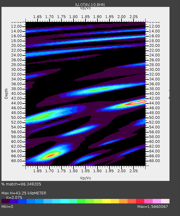
OTAV Otavalu, Ecuador - Earthquake Result Viewer
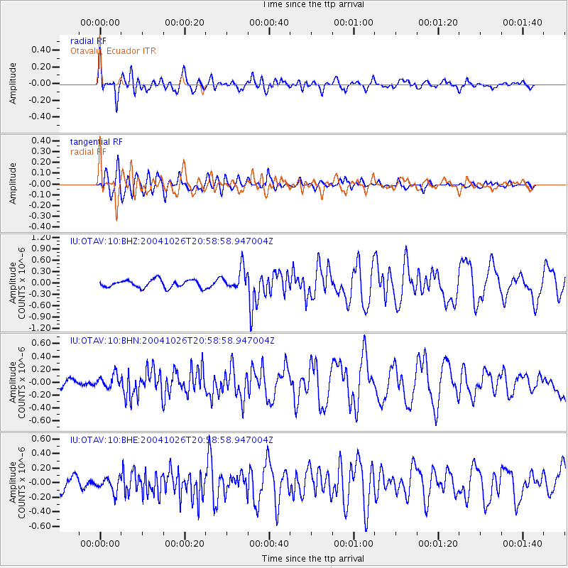
Earthquake location: South Sandwich Islands Region
Earthquake latitude/longitude: -57.1/-24.8
Earthquake time(UTC): 2004/10/26 (300) 20:48:10 GMT
Earthquake Depth: 10 km
Earthquake Magnitude: 5.4 MB, 5.5 MS, 6.0 MW, 5.7 MW
Earthquake Catalog/Contributor: WHDF/NEIC
Network: IU Global Seismograph Network (GSN - IRIS/USGS)
Station: OTAV Otavalu, Ecuador
Lat/Lon: 0.24 N/78.45 W
Elevation: 3507 m
Distance: 71.3 deg
Az: 301.793 deg
Baz: 152.337 deg
Ray Param: 0.054416936
Estimated Moho Depth: 43.25 km
Estimated Crust Vp/Vs: 2.08
Assumed Crust Vp: 6.472 km/s
Estimated Crust Vs: 3.119 km/s
Estimated Crust Poisson's Ratio: 0.35
Radial Match: 86.349205 %
Radial Bump: 400
Transverse Match: 74.77274 %
Transverse Bump: 400
SOD ConfigId: 2459
Insert Time: 2010-03-04 20:34:04.539 +0000
GWidth: 2.5
Max Bumps: 400
Tol: 0.001

Signal To Noise

ChannelStoNSTALTA
IU:OTAV:10:BHN:20041026T20:58:58.947004Z1.1713189.514184E-88.122632E-8
IU:OTAV:10:BHE:20041026T20:58:58.947004Z1.31676691.0021262E-77.610505E-8
IU:OTAV:10:BHZ:20041026T20:58:58.947004Z2.89336732.9463587E-71.0183148E-7
Arrivals
Ps7.4 SECOND
PpPs20 SECOND
PsPs/PpSs27 SECOND