You are here: Home > Network List > IU - Global Seismograph Network (GSN - IRIS/USGS) Stations List
> Station OTAV Otavalu, Ecuador > Earthquake Result Viewer
OTAV Otavalu, Ecuador - Earthquake Result Viewer
| Earthquake location: |
Gulf Of California |
| Earthquake latitude/longitude: |
28.2/-112.1 |
| Earthquake time(UTC): |
2006/01/04 (004) 08:32:32 GMT |
| Earthquake Depth: |
14 km |
| Earthquake Magnitude: |
6.1 MB, 6.7 MS, 6.6 MW, 6.5 MW |
| Earthquake Catalog/Contributor: |
WHDF/NEIC |
|
| Network: |
IU Global Seismograph Network (GSN - IRIS/USGS) |
| Station: |
OTAV Otavalu, Ecuador |
| Lat/Lon: |
0.24 N/78.45 W |
| Elevation: |
3507 m |
|
| Distance: |
42.5 deg |
| Az: |
124.93 deg |
| Baz: |
313.625 deg |
| Ray Param: |
0.07310416 |
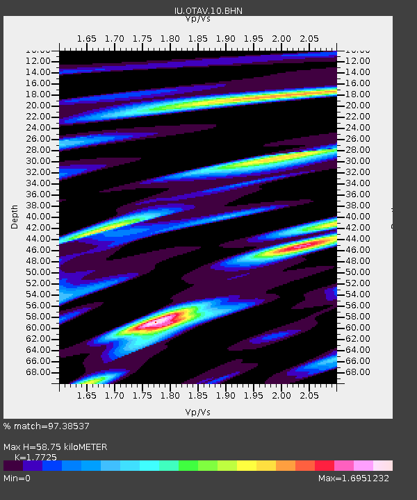
| Estimated Moho Depth: |
58.75 km |
| Estimated Crust Vp/Vs: |
1.77 |
| Assumed Crust Vp: |
6.472 km/s |
| Estimated Crust Vs: |
3.651 km/s |
| Estimated Crust Poisson's Ratio: |
0.27 |
|
| Radial Match: |
97.38537 % |
| Radial Bump: |
347 |
| Transverse Match: |
89.81919 % |
| Transverse Bump: |
400 |
| SOD ConfigId: |
4977 |
| Insert Time: |
2010-03-04 20:34:18.728 +0000 |
| GWidth: |
2.5 |
| Max Bumps: |
400 |
| Tol: |
0.001 |
|
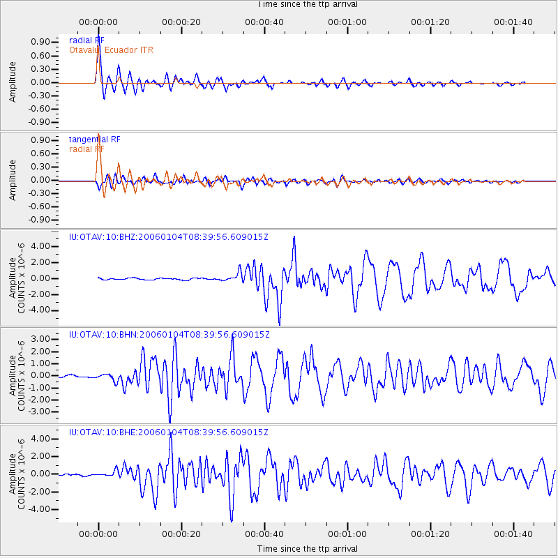
Signal To Noise
| Channel | StoN | STA | LTA |
| IU:OTAV:10:BHN:20060104T08:39:56.609015Z | 3.4256718 | 2.992118E-7 | 8.734397E-8 |
| IU:OTAV:10:BHE:20060104T08:39:56.609015Z | 5.9802155 | 3.394497E-7 | 5.6762122E-8 |
| IU:OTAV:10:BHZ:20060104T08:39:56.609015Z | 5.5899725 | 5.725662E-7 | 1.0242737E-7 |
| Arrivals |
| Ps | 7.5 SECOND |
| PpPs | 24 SECOND |
| PsPs/PpSs | 31 SECOND |


