You are here: Home > Network List > IU - Global Seismograph Network (GSN - IRIS/USGS) Stations List
> Station PTCN Pitcairn Island, South Pacific > Earthquake Result Viewer
PTCN Pitcairn Island, South Pacific - Earthquake Result Viewer
| Earthquake location: |
Jujuy Province, Argentina |
| Earthquake latitude/longitude: |
-23.5/-66.5 |
| Earthquake time(UTC): |
2000/05/12 (133) 18:43:18 GMT |
| Earthquake Depth: |
225 km |
| Earthquake Magnitude: |
6.2 MB, 7.2 MW, 7.1 MW |
| Earthquake Catalog/Contributor: |
WHDF/NEIC |
|
| Network: |
IU Global Seismograph Network (GSN - IRIS/USGS) |
| Station: |
PTCN Pitcairn Island, South Pacific |
| Lat/Lon: |
25.07 S/130.10 W |
| Elevation: |
220 m |
|
| Distance: |
57.5 deg |
| Az: |
254.406 deg |
| Baz: |
102.916 deg |
| Ray Param: |
0.0626821 |
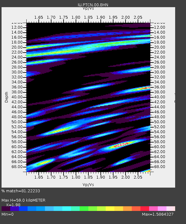
| Estimated Moho Depth: |
59.0 km |
| Estimated Crust Vp/Vs: |
1.98 |
| Assumed Crust Vp: |
4.24 km/s |
| Estimated Crust Vs: |
2.141 km/s |
| Estimated Crust Poisson's Ratio: |
0.33 |
|
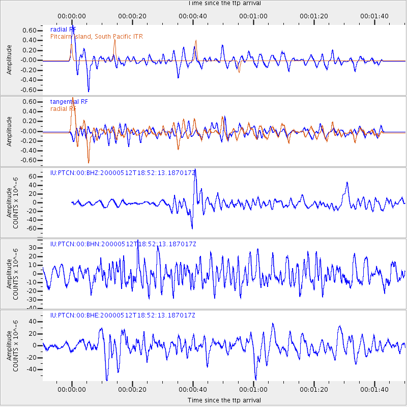
| Radial Match: |
81.22233 % |
| Radial Bump: |
400 |
| Transverse Match: |
59.19178 % |
| Transverse Bump: |
400 |
| SOD ConfigId: |
3744 |
| Insert Time: |
2010-03-04 20:34:28.515 +0000 |
| GWidth: |
2.5 |
| Max Bumps: |
400 |
| Tol: |
0.001 |
|
Signal To Noise
| Channel | StoN | STA | LTA |
| IU:PTCN:00:BHN:20000512T18:52:13.187017Z | 0.6076097 | 5.394318E-6 | 8.8779325E-6 |
| IU:PTCN:00:BHE:20000512T18:52:13.187017Z | 1.1938128 | 6.885205E-6 | 5.767407E-6 |
| IU:PTCN:00:BHZ:20000512T18:52:13.187017Z | 2.348202 | 1.0045104E-5 | 4.2777856E-6 |
| Arrivals |
| Ps | 14 SECOND |
| PpPs | 41 SECOND |
| PsPs/PpSs | 55 SECOND |


