You are here: Home > Network List > IU - Global Seismograph Network (GSN - IRIS/USGS) Stations List
> Station PTCN Pitcairn Island, South Pacific > Earthquake Result Viewer
PTCN Pitcairn Island, South Pacific - Earthquake Result Viewer
| Earthquake location: |
Near Coast Of Peru |
| Earthquake latitude/longitude: |
-16.3/-73.6 |
| Earthquake time(UTC): |
2001/06/23 (174) 20:33:14 GMT |
| Earthquake Depth: |
33 km |
| Earthquake Magnitude: |
6.7 MB, 8.2 MS, 8.4 MW, 7.8 ME |
| Earthquake Catalog/Contributor: |
WHDF/NEIC |
|
| Network: |
IU Global Seismograph Network (GSN - IRIS/USGS) |
| Station: |
PTCN Pitcairn Island, South Pacific |
| Lat/Lon: |
25.07 S/130.10 W |
| Elevation: |
220 m |
|
| Distance: |
53.2 deg |
| Az: |
250.661 deg |
| Baz: |
92.057 deg |
| Ray Param: |
0.066177964 |
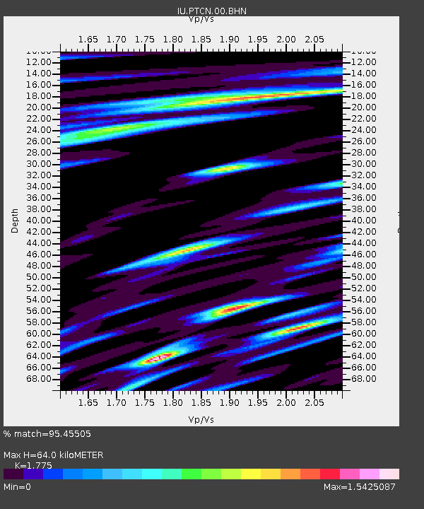
| Estimated Moho Depth: |
64.0 km |
| Estimated Crust Vp/Vs: |
1.77 |
| Assumed Crust Vp: |
4.24 km/s |
| Estimated Crust Vs: |
2.389 km/s |
| Estimated Crust Poisson's Ratio: |
0.27 |
|
| Radial Match: |
95.45505 % |
| Radial Bump: |
351 |
| Transverse Match: |
77.68515 % |
| Transverse Bump: |
400 |
| SOD ConfigId: |
4714 |
| Insert Time: |
2010-03-04 20:34:33.247 +0000 |
| GWidth: |
2.5 |
| Max Bumps: |
400 |
| Tol: |
0.001 |
|
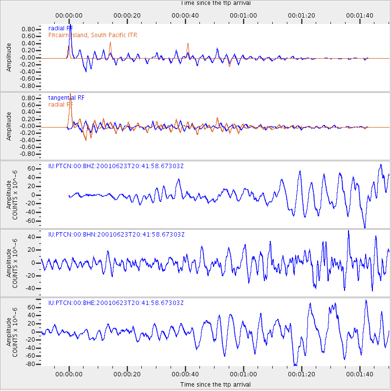
Signal To Noise
| Channel | StoN | STA | LTA |
| IU:PTCN:00:BHN:20010623T20:41:58.67303Z | 1.2194637 | 4.821295E-6 | 3.953619E-6 |
| IU:PTCN:00:BHE:20010623T20:41:58.67303Z | 1.3409355 | 6.3862985E-6 | 4.7625695E-6 |
| IU:PTCN:00:BHZ:20010623T20:41:58.67303Z | 2.2384691 | 1.20629575E-5 | 5.388932E-6 |
| Arrivals |
| Ps | 12 SECOND |
| PpPs | 41 SECOND |
| PsPs/PpSs | 53 SECOND |


