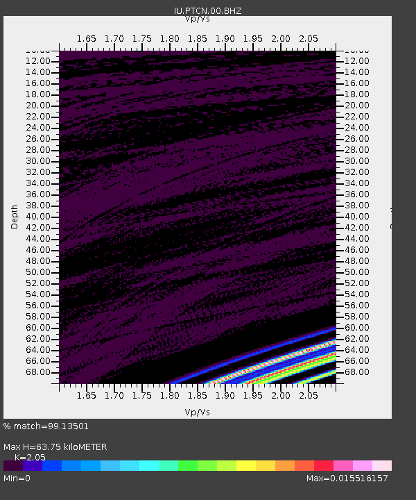
PTCN Pitcairn Island, South Pacific - Earthquake Result Viewer
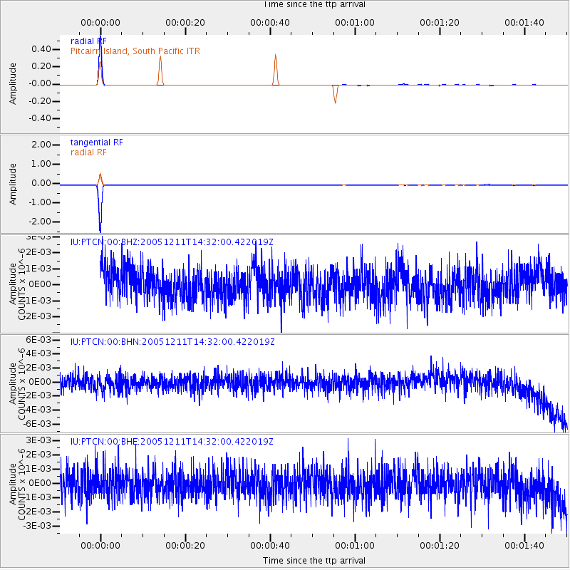
Earthquake location: New Britain Region, P.N.G.
Earthquake latitude/longitude: -6.6/152.2
Earthquake time(UTC): 2005/12/11 (345) 14:20:43 GMT
Earthquake Depth: 10 km
Earthquake Magnitude: 6.2 MB, 6.2 MS, 6.6 MW, 6.5 MW
Earthquake Catalog/Contributor: WHDF/NEIC
Network: IU Global Seismograph Network (GSN - IRIS/USGS)
Station: PTCN Pitcairn Island, South Pacific
Lat/Lon: 25.07 S/130.10 W
Elevation: 220 m
Distance: 76.1 deg
Az: 114.121 deg
Baz: 269.178 deg
Ray Param: 0.0511996
Estimated Moho Depth: 63.75 km
Estimated Crust Vp/Vs: 2.05
Assumed Crust Vp: 4.24 km/s
Estimated Crust Vs: 2.068 km/s
Estimated Crust Poisson's Ratio: 0.34
Radial Match: 99.13501 %
Radial Bump: 40
Transverse Match: 99.75384 %
Transverse Bump: 26
SOD ConfigId: 2669
Insert Time: 2010-03-04 20:34:39.207 +0000
GWidth: 2.5
Max Bumps: 400
Tol: 0.001

Signal To Noise

ChannelStoNSTALTA
IU:PTCN:00:BHN:20051211T14:32:00.422019Z1.12275061.1626E-91.0354926E-9
IU:PTCN:00:BHE:20051211T14:32:00.422019Z1.01705319.55572E-109.395497E-10
IU:PTCN:00:BHZ:20051211T14:32:00.422019Z0.90547218.621304E-109.521336E-10
Arrivals
Ps16 SECOND
PpPs45 SECOND
PsPs/PpSs61 SECOND