You are here: Home > Network List > US - United States National Seismic Network Stations List
> Station TPNV Topopah Spring, Nevada, USA > Earthquake Result Viewer
TPNV Topopah Spring, Nevada, USA - Earthquake Result Viewer

| Earthquake location: |
Santa Cruz Islands Region |
| Earthquake latitude/longitude: |
-10.9/164.2 |
| Earthquake time(UTC): |
2015/05/20 (140) 22:48:53 GMT |
| Earthquake Depth: |
12 km |
| Earthquake Magnitude: |
6.8 MWW, 6.7 MWB, 6.8 MWC, 6.9 MI |
| Earthquake Catalog/Contributor: |
NEIC PDE/NEIC COMCAT |
|
| Network: |
US United States National Seismic Network |
| Station: |
TPNV Topopah Spring, Nevada, USA |
| Lat/Lon: |
36.95 N/116.25 W |
| Elevation: |
1600 m |
|
| Distance: |
88.3 deg |
| Az: |
52.025 deg |
| Baz: |
255.128 deg |
| Ray Param: |
0.042692184 |
| Estimated Moho Depth: |
62.5 km |
| Estimated Crust Vp/Vs: |
1.88 |
| Assumed Crust Vp: |
6.279 km/s |
| Estimated Crust Vs: |
3.331 km/s |
| Estimated Crust Poisson's Ratio: |
0.30 |
|
| Radial Match: |
91.658195 % |
| Radial Bump: |
400 |
| Transverse Match: |
86.21722 % |
| Transverse Bump: |
400 |
| SOD ConfigId: |
976571 |
| Insert Time: |
2015-06-03 23:00:05.789 +0000 |
| GWidth: |
2.5 |
| Max Bumps: |
400 |
| Tol: |
0.001 |
|
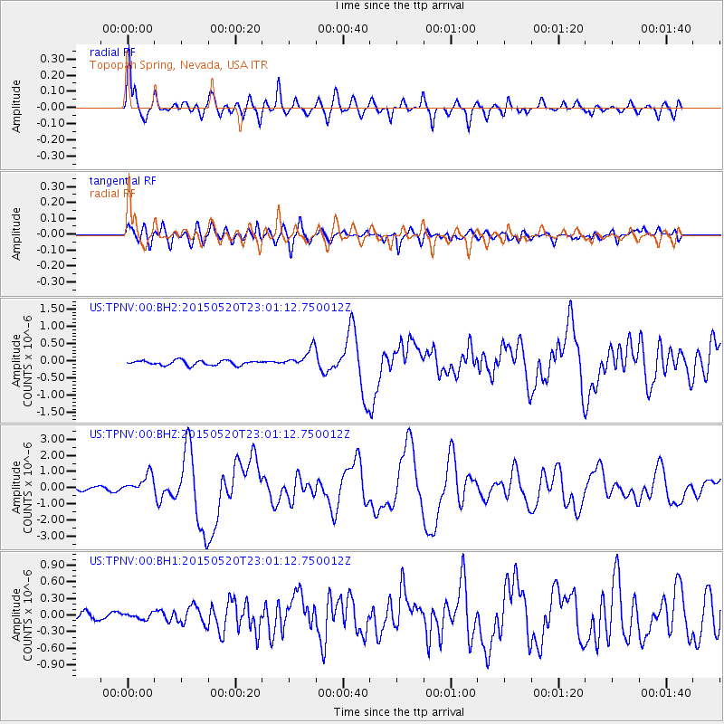
Signal To Noise
| Channel | StoN | STA | LTA |
| US:TPNV:00:BHZ:20150520T23:01:12.750012Z | 6.072569 | 6.040621E-7 | 9.94739E-8 |
| US:TPNV:00:BH1:20150520T23:01:12.750012Z | 0.43314302 | 5.4224063E-8 | 1.2518743E-7 |
| US:TPNV:00:BH2:20150520T23:01:12.750012Z | 4.0573926 | 2.7584701E-7 | 6.798628E-8 |
| Arrivals |
| Ps | 9.0 SECOND |
| PpPs | 28 SECOND |
| PsPs/PpSs | 37 SECOND |


