You are here: Home > Network List > US - United States National Seismic Network Stations List
> Station WRAK Wrangell Island, Southeastern Alaska, Alaska, USA > Earthquake Result Viewer
WRAK Wrangell Island, Southeastern Alaska, Alaska, USA - Earthquake Result Viewer

| Earthquake location: |
Santa Cruz Islands Region |
| Earthquake latitude/longitude: |
-10.9/164.2 |
| Earthquake time(UTC): |
2015/05/20 (140) 22:48:53 GMT |
| Earthquake Depth: |
12 km |
| Earthquake Magnitude: |
6.8 MWW, 6.7 MWB, 6.8 MWC, 6.9 MI |
| Earthquake Catalog/Contributor: |
NEIC PDE/NEIC COMCAT |
|
| Network: |
US United States National Seismic Network |
| Station: |
WRAK Wrangell Island, Southeastern Alaska, Alaska, USA |
| Lat/Lon: |
56.42 N/132.35 W |
| Elevation: |
81 m |
|
| Distance: |
85.0 deg |
| Az: |
29.947 deg |
| Baz: |
241.931 deg |
| Ray Param: |
0.04509183 |
| Estimated Moho Depth: |
69.75 km |
| Estimated Crust Vp/Vs: |
1.90 |
| Assumed Crust Vp: |
6.597 km/s |
| Estimated Crust Vs: |
3.468 km/s |
| Estimated Crust Poisson's Ratio: |
0.31 |
|
| Radial Match: |
95.822296 % |
| Radial Bump: |
400 |
| Transverse Match: |
82.21529 % |
| Transverse Bump: |
400 |
| SOD ConfigId: |
976571 |
| Insert Time: |
2015-06-03 23:00:05.792 +0000 |
| GWidth: |
2.5 |
| Max Bumps: |
400 |
| Tol: |
0.001 |
|
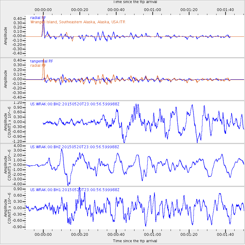
Signal To Noise
| Channel | StoN | STA | LTA |
| US:WRAK:00:BHZ:20150520T23:00:56.599988Z | 6.3151126 | 6.457176E-7 | 1.0224957E-7 |
| US:WRAK:00:BH1:20150520T23:00:56.599988Z | 1.8970762 | 1.1330328E-7 | 5.972521E-8 |
| US:WRAK:00:BH2:20150520T23:00:56.599988Z | 2.3812475 | 2.2580903E-7 | 9.482803E-8 |
| Arrivals |
| Ps | 9.8 SECOND |
| PpPs | 30 SECOND |
| PsPs/PpSs | 40 SECOND |


