You are here: Home > Network List > IU - Global Seismograph Network (GSN - IRIS/USGS) Stations List
> Station PTCN Pitcairn Island, South Pacific > Earthquake Result Viewer
PTCN Pitcairn Island, South Pacific - Earthquake Result Viewer
| Earthquake location: |
Eastern New Guinea Reg., P.N.G. |
| Earthquake latitude/longitude: |
-5.2/145.3 |
| Earthquake time(UTC): |
2005/11/22 (326) 15:11:31 GMT |
| Earthquake Depth: |
68 km |
| Earthquake Magnitude: |
6.0 MB, 6.2 MW, 6.2 MW |
| Earthquake Catalog/Contributor: |
WHDF/NEIC |
|
| Network: |
IU Global Seismograph Network (GSN - IRIS/USGS) |
| Station: |
PTCN Pitcairn Island, South Pacific |
| Lat/Lon: |
25.07 S/130.10 W |
| Elevation: |
220 m |
|
| Distance: |
83.0 deg |
| Az: |
114.536 deg |
| Baz: |
267.599 deg |
| Ray Param: |
0.046381533 |
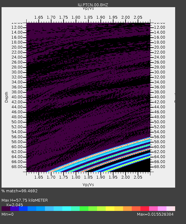
| Estimated Moho Depth: |
57.75 km |
| Estimated Crust Vp/Vs: |
2.05 |
| Assumed Crust Vp: |
4.24 km/s |
| Estimated Crust Vs: |
2.073 km/s |
| Estimated Crust Poisson's Ratio: |
0.34 |
|
| Radial Match: |
99.4692 % |
| Radial Bump: |
39 |
| Transverse Match: |
99.756874 % |
| Transverse Bump: |
21 |
| SOD ConfigId: |
2669 |
| Insert Time: |
2010-03-04 20:34:51.407 +0000 |
| GWidth: |
2.5 |
| Max Bumps: |
400 |
| Tol: |
0.001 |
|
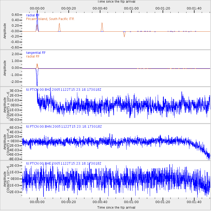
Signal To Noise
| Channel | StoN | STA | LTA |
| IU:PTCN:00:BHN:20051122T15:23:18.173018Z | 0.95025295 | 1.0048495E-9 | 1.0574548E-9 |
| IU:PTCN:00:BHE:20051122T15:23:18.173018Z | 1.110769 | 9.373484E-10 | 8.4387336E-10 |
| IU:PTCN:00:BHZ:20051122T15:23:18.173018Z | 0.8622295 | 8.342354E-10 | 9.675329E-10 |
| Arrivals |
| Ps | 14 SECOND |
| PpPs | 41 SECOND |
| PsPs/PpSs | 55 SECOND |


