You are here: Home > Network List > IU - Global Seismograph Network (GSN - IRIS/USGS) Stations List
> Station PTCN Pitcairn Island, South Pacific > Earthquake Result Viewer
PTCN Pitcairn Island, South Pacific - Earthquake Result Viewer
| Earthquake location: |
Solomon Islands |
| Earthquake latitude/longitude: |
-10.5/161.0 |
| Earthquake time(UTC): |
2005/11/10 (314) 09:23:20 GMT |
| Earthquake Depth: |
68 km |
| Earthquake Magnitude: |
5.3 MB, 5.5 MW |
| Earthquake Catalog/Contributor: |
WHDF/NEIC |
|
| Network: |
IU Global Seismograph Network (GSN - IRIS/USGS) |
| Station: |
PTCN Pitcairn Island, South Pacific |
| Lat/Lon: |
25.07 S/130.10 W |
| Elevation: |
220 m |
|
| Distance: |
66.6 deg |
| Az: |
112.776 deg |
| Baz: |
269.064 deg |
| Ray Param: |
0.05737723 |
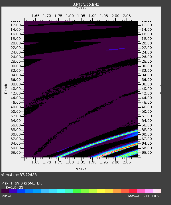
| Estimated Moho Depth: |
69.0 km |
| Estimated Crust Vp/Vs: |
1.94 |
| Assumed Crust Vp: |
4.24 km/s |
| Estimated Crust Vs: |
2.183 km/s |
| Estimated Crust Poisson's Ratio: |
0.32 |
|
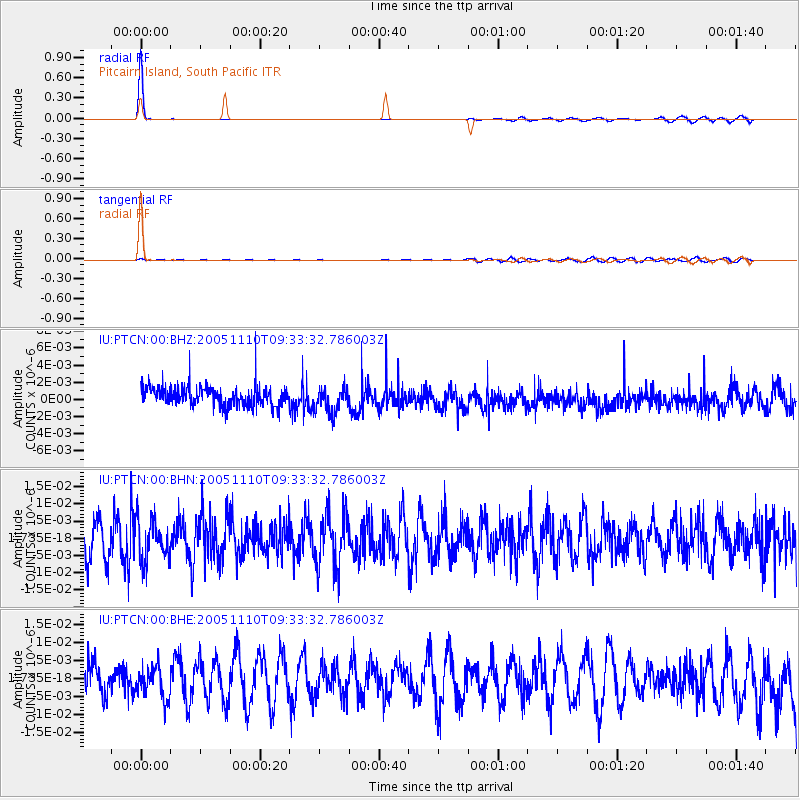
| Radial Match: |
87.72638 % |
| Radial Bump: |
107 |
| Transverse Match: |
36.98567 % |
| Transverse Bump: |
297 |
| SOD ConfigId: |
2669 |
| Insert Time: |
2010-03-04 20:34:53.445 +0000 |
| GWidth: |
2.5 |
| Max Bumps: |
400 |
| Tol: |
0.001 |
|
Signal To Noise
| Channel | StoN | STA | LTA |
| IU:PTCN:00:BHN:20051110T09:33:32.786003Z | 0.9427781 | 5.744115E-9 | 6.0927534E-9 |
| IU:PTCN:00:BHE:20051110T09:33:32.786003Z | 1.0412287 | 4.5339816E-9 | 4.3544537E-9 |
| IU:PTCN:00:BHZ:20051110T09:33:32.786003Z | 1.306941 | 1.4915065E-9 | 1.1412193E-9 |
| Arrivals |
| Ps | 16 SECOND |
| PpPs | 47 SECOND |
| PsPs/PpSs | 63 SECOND |


