You are here: Home > Network List > IU - Global Seismograph Network (GSN - IRIS/USGS) Stations List
> Station PTCN Pitcairn Island, South Pacific > Earthquake Result Viewer
PTCN Pitcairn Island, South Pacific - Earthquake Result Viewer
| Earthquake location: |
Northern Peru |
| Earthquake latitude/longitude: |
-5.7/-76.4 |
| Earthquake time(UTC): |
2005/09/26 (269) 01:55:37 GMT |
| Earthquake Depth: |
115 km |
| Earthquake Magnitude: |
6.7 MB, 7.5 MW, 7.5 MW |
| Earthquake Catalog/Contributor: |
WHDF/NEIC |
|
| Network: |
IU Global Seismograph Network (GSN - IRIS/USGS) |
| Station: |
PTCN Pitcairn Island, South Pacific |
| Lat/Lon: |
25.07 S/130.10 W |
| Elevation: |
220 m |
|
| Distance: |
54.8 deg |
| Az: |
243.361 deg |
| Baz: |
78.775 deg |
| Ray Param: |
0.06481704 |
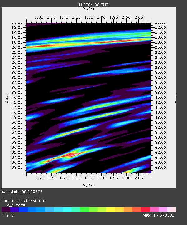
| Estimated Moho Depth: |
62.5 km |
| Estimated Crust Vp/Vs: |
1.80 |
| Assumed Crust Vp: |
4.24 km/s |
| Estimated Crust Vs: |
2.359 km/s |
| Estimated Crust Poisson's Ratio: |
0.28 |
|
| Radial Match: |
89.190636 % |
| Radial Bump: |
400 |
| Transverse Match: |
66.45602 % |
| Transverse Bump: |
400 |
| SOD ConfigId: |
2475 |
| Insert Time: |
2010-03-04 20:34:54.469 +0000 |
| GWidth: |
2.5 |
| Max Bumps: |
400 |
| Tol: |
0.001 |
|

Signal To Noise
| Channel | StoN | STA | LTA |
| IU:PTCN:00:BHN:20050926T02:04:25.422014Z | 0.9737988 | 2.4881062E-6 | 2.5550517E-6 |
| IU:PTCN:00:BHE:20050926T02:04:25.422014Z | 2.0869327 | 4.38535E-6 | 2.1013377E-6 |
| IU:PTCN:00:BHZ:20050926T02:04:25.422014Z | 2.3850784 | 4.3918144E-6 | 1.841371E-6 |
| Arrivals |
| Ps | 12 SECOND |
| PpPs | 40 SECOND |
| PsPs/PpSs | 52 SECOND |


