You are here: Home > Network List > IU - Global Seismograph Network (GSN - IRIS/USGS) Stations List
> Station SFJ Sondre Stromfjord, Greenland > Earthquake Result Viewer
SFJ Sondre Stromfjord, Greenland - Earthquake Result Viewer
| Earthquake location: |
Near Coast Of Peru |
| Earthquake latitude/longitude: |
-16.7/-72.7 |
| Earthquake time(UTC): |
1999/04/03 (093) 06:17:18 GMT |
| Earthquake Depth: |
87 km |
| Earthquake Magnitude: |
6.1 MB, 6.2 MS, 6.8 MW, 6.8 MW |
| Earthquake Catalog/Contributor: |
WHDF/NEIC |
|
| Network: |
IU Global Seismograph Network (GSN - IRIS/USGS) |
| Station: |
SFJ Sondre Stromfjord, Greenland |
| Lat/Lon: |
67.00 N/50.62 W |
| Elevation: |
365 m |
|
| Distance: |
85.0 deg |
| Az: |
8.516 deg |
| Baz: |
201.172 deg |
| Ray Param: |
0.04489904 |
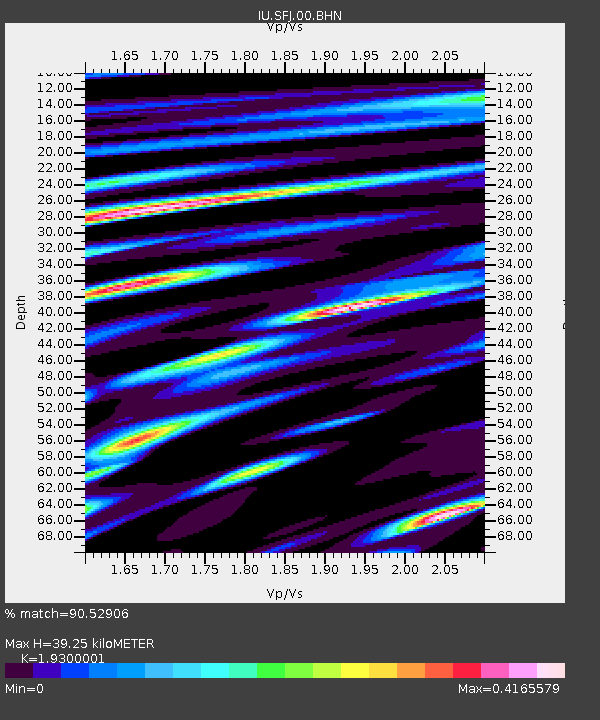
| Estimated Moho Depth: |
39.25 km |
| Estimated Crust Vp/Vs: |
1.93 |
| Assumed Crust Vp: |
6.459 km/s |
| Estimated Crust Vs: |
3.347 km/s |
| Estimated Crust Poisson's Ratio: |
0.32 |
|
| Radial Match: |
90.52906 % |
| Radial Bump: |
400 |
| Transverse Match: |
81.52014 % |
| Transverse Bump: |
400 |
| SOD ConfigId: |
4480 |
| Insert Time: |
2010-03-04 20:35:57.752 +0000 |
| GWidth: |
2.5 |
| Max Bumps: |
400 |
| Tol: |
0.001 |
|

Signal To Noise
| Channel | StoN | STA | LTA |
| IU:SFJ:00:BHN:19990403T06:29:12.972Z | 3.2273746 | 1.0341818E-6 | 3.204406E-7 |
| IU:SFJ:00:BHE:19990403T06:29:12.972Z | 1.6868017 | 3.6723833E-7 | 2.1771281E-7 |
| IU:SFJ:00:BHZ:19990403T06:29:12.972Z | 0.84194905 | 2.1143642E-7 | 2.5112735E-7 |
| Arrivals |
| Ps | 5.8 SECOND |
| PpPs | 17 SECOND |
| PsPs/PpSs | 23 SECOND |


