You are here: Home > Network List > IU - Global Seismograph Network (GSN - IRIS/USGS) Stations List
> Station SFJ Sondre Stromfjord, Greenland > Earthquake Result Viewer
SFJ Sondre Stromfjord, Greenland - Earthquake Result Viewer
| Earthquake location: |
Washington |
| Earthquake latitude/longitude: |
47.1/-122.7 |
| Earthquake time(UTC): |
2001/02/28 (059) 18:54:32 GMT |
| Earthquake Depth: |
52 km |
| Earthquake Magnitude: |
6.5 MB, 6.6 MS, 6.8 MW, 6.7 ME |
| Earthquake Catalog/Contributor: |
WHDF/NEIC |
|
| Network: |
IU Global Seismograph Network (GSN - IRIS/USGS) |
| Station: |
SFJ Sondre Stromfjord, Greenland |
| Lat/Lon: |
67.00 N/50.62 W |
| Elevation: |
365 m |
|
| Distance: |
41.0 deg |
| Az: |
34.737 deg |
| Baz: |
278.273 deg |
| Ray Param: |
0.07390647 |
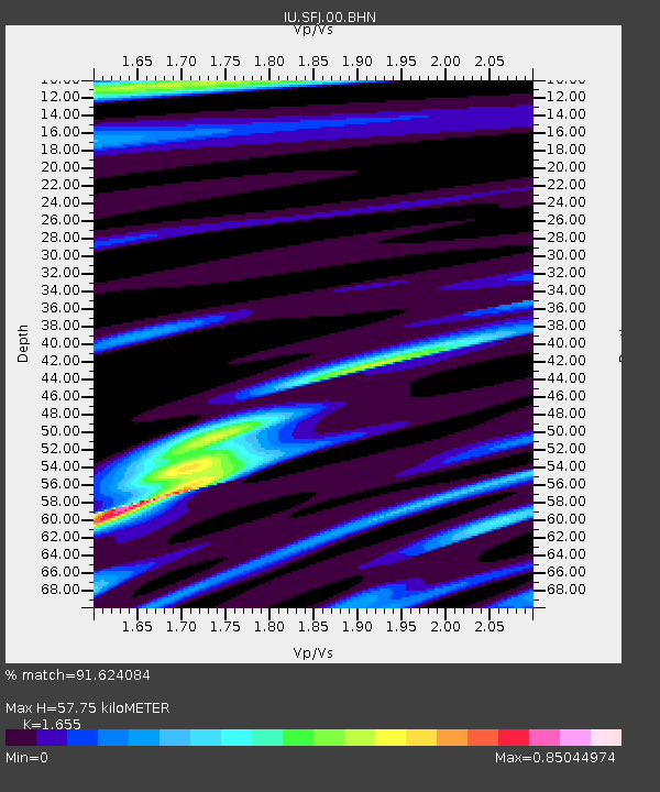
| Estimated Moho Depth: |
57.75 km |
| Estimated Crust Vp/Vs: |
1.65 |
| Assumed Crust Vp: |
6.459 km/s |
| Estimated Crust Vs: |
3.903 km/s |
| Estimated Crust Poisson's Ratio: |
0.21 |
|
| Radial Match: |
91.624084 % |
| Radial Bump: |
373 |
| Transverse Match: |
69.574524 % |
| Transverse Bump: |
400 |
| SOD ConfigId: |
3744 |
| Insert Time: |
2010-03-04 20:36:08.908 +0000 |
| GWidth: |
2.5 |
| Max Bumps: |
400 |
| Tol: |
0.001 |
|

Signal To Noise
| Channel | StoN | STA | LTA |
| IU:SFJ:00:BHN:20010228T19:01:40.586012Z | 4.6911907 | 9.98774E-7 | 2.1290415E-7 |
| IU:SFJ:00:BHE:20010228T19:01:40.586012Z | 5.9721913 | 2.505861E-6 | 4.195882E-7 |
| IU:SFJ:00:BHZ:20010228T19:01:40.586012Z | 15.462477 | 4.2638735E-6 | 2.7575618E-7 |
| Arrivals |
| Ps | 6.3 SECOND |
| PpPs | 22 SECOND |
| PsPs/PpSs | 28 SECOND |


