You are here: Home > Network List > TA - USArray Transportable Network (new EarthScope stations) Stations List
> Station W41B Gary Mavity, Velonia, AR, USA > Earthquake Result Viewer
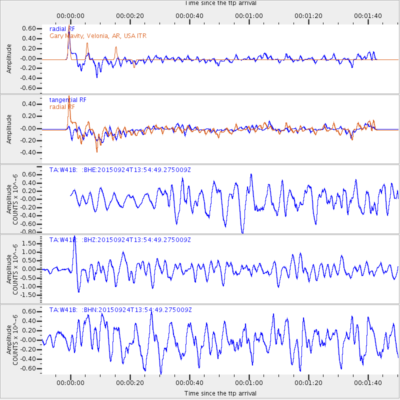
W41B Gary Mavity, Velonia, AR, USA - Earthquake Result Viewer
*The percent match for this event was below the threshold and hence no stack was calculated.
| Earthquake location: |
Vancouver Island, Canada Region |
| Earthquake latitude/longitude: |
50.7/-130.2 |
| Earthquake time(UTC): |
2015/09/24 (267) 13:48:58 GMT |
| Earthquake Depth: |
10 km |
| Earthquake Magnitude: |
5.5 MB, 5.6 MI |
| Earthquake Catalog/Contributor: |
NEIC PDE/NEIC COMCAT |
|
| Network: |
TA USArray Transportable Network (new EarthScope stations) |
| Station: |
W41B Gary Mavity, Velonia, AR, USA |
| Lat/Lon: |
35.17 N/92.25 W |
| Elevation: |
95 m |
|
| Distance: |
31.4 deg |
| Az: |
104.894 deg |
| Baz: |
311.44 deg |
| Ray Param: |
$rayparam |
*The percent match for this event was below the threshold and hence was not used in the summary stack. |
|
| Radial Match: |
69.95272 % |
| Radial Bump: |
400 |
| Transverse Match: |
46.766098 % |
| Transverse Bump: |
400 |
| SOD ConfigId: |
7422571 |
| Insert Time: |
2019-04-21 00:19:48.657 +0000 |
| GWidth: |
2.5 |
| Max Bumps: |
400 |
| Tol: |
0.001 |
|
Signal To Noise
| Channel | StoN | STA | LTA |
| TA:W41B: :BHZ:20150924T13:54:49.275009Z | 6.110574 | 8.0637653E-7 | 1.3196413E-7 |
| TA:W41B: :BHN:20150924T13:54:49.275009Z | 1.1828383 | 3.2391233E-7 | 2.7384328E-7 |
| TA:W41B: :BHE:20150924T13:54:49.275009Z | 1.5314894 | 2.1044035E-7 | 1.3740895E-7 |
| Arrivals |
| Ps | |
| PpPs | |
| PsPs/PpSs | |


