You are here: Home > Network List > WY - Yellowstone Wyoming Seismic Network Stations List
> Station YPP Pitchstone Plateau, YNP, WY, USA > Earthquake Result Viewer
YPP Pitchstone Plateau, YNP, WY, USA - Earthquake Result Viewer
| Earthquake location: |
Santa Cruz Islands Region |
| Earthquake latitude/longitude: |
-10.9/164.2 |
| Earthquake time(UTC): |
2015/05/20 (140) 22:48:53 GMT |
| Earthquake Depth: |
12 km |
| Earthquake Magnitude: |
6.8 MWW, 6.7 MWB, 6.8 MWC, 6.9 MI |
| Earthquake Catalog/Contributor: |
NEIC PDE/NEIC COMCAT |
|
| Network: |
WY Yellowstone Wyoming Seismic Network |
| Station: |
YPP Pitchstone Plateau, YNP, WY, USA |
| Lat/Lon: |
44.27 N/110.80 W |
| Elevation: |
2707 m |
|
| Distance: |
94.0 deg |
| Az: |
45.843 deg |
| Baz: |
258.79 deg |
| Ray Param: |
0.041147377 |
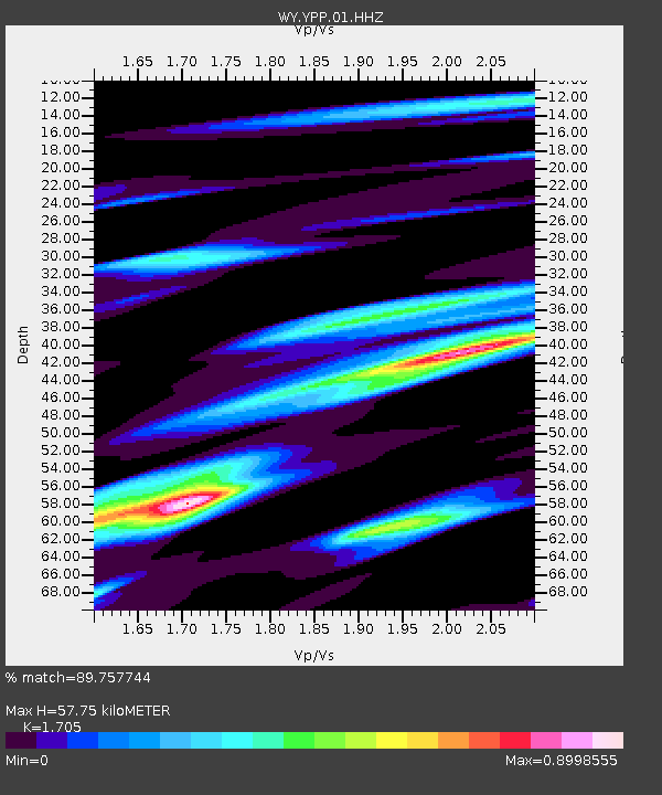
| Estimated Moho Depth: |
57.75 km |
| Estimated Crust Vp/Vs: |
1.71 |
| Assumed Crust Vp: |
6.35 km/s |
| Estimated Crust Vs: |
3.724 km/s |
| Estimated Crust Poisson's Ratio: |
0.24 |
|
| Radial Match: |
89.757744 % |
| Radial Bump: |
400 |
| Transverse Match: |
90.112854 % |
| Transverse Bump: |
400 |
| SOD ConfigId: |
976571 |
| Insert Time: |
2015-06-03 23:01:41.776 +0000 |
| GWidth: |
2.5 |
| Max Bumps: |
400 |
| Tol: |
0.001 |
|

Signal To Noise
| Channel | StoN | STA | LTA |
| WY:YPP:01:HHZ:20150520T23:01:39.078015Z | 4.89534 | 5.910778E-9 | 1.2074295E-9 |
| WY:YPP:01:HHN:20150520T23:01:39.078015Z | 2.2874606 | 2.6233138E-9 | 1.1468236E-9 |
| WY:YPP:01:HHE:20150520T23:01:39.078015Z | 2.9453502 | 4.298699E-9 | 1.4594866E-9 |
| Arrivals |
| Ps | 6.5 SECOND |
| PpPs | 24 SECOND |
| PsPs/PpSs | 31 SECOND |


