You are here: Home > Network List > AK - Alaska Regional Network Stations List
> Station TABL Table Mountain, AK, USA > Earthquake Result Viewer
TABL Table Mountain, AK, USA - Earthquake Result Viewer
| Earthquake location: |
Irian Jaya Region, Indonesia |
| Earthquake latitude/longitude: |
-0.6/131.3 |
| Earthquake time(UTC): |
2015/09/24 (267) 15:53:28 GMT |
| Earthquake Depth: |
24 km |
| Earthquake Magnitude: |
6.6 MWW, 6.4 MWB, 6.9 MI |
| Earthquake Catalog/Contributor: |
NEIC PDE/NEIC COMCAT |
|
| Network: |
AK Alaska Regional Network |
| Station: |
TABL Table Mountain, AK, USA |
| Lat/Lon: |
60.44 N/141.14 W |
| Elevation: |
2050 m |
|
| Distance: |
89.4 deg |
| Az: |
29.699 deg |
| Baz: |
267.607 deg |
| Ray Param: |
0.0418875 |
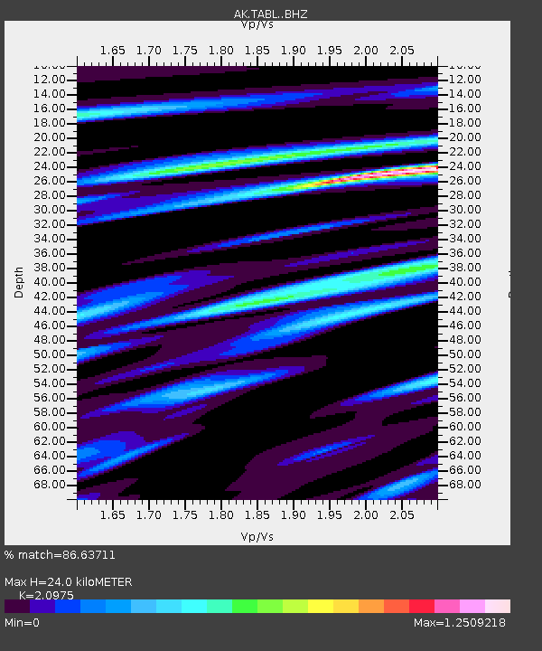
| Estimated Moho Depth: |
24.0 km |
| Estimated Crust Vp/Vs: |
2.10 |
| Assumed Crust Vp: |
6.566 km/s |
| Estimated Crust Vs: |
3.13 km/s |
| Estimated Crust Poisson's Ratio: |
0.35 |
|
| Radial Match: |
86.63711 % |
| Radial Bump: |
400 |
| Transverse Match: |
80.54531 % |
| Transverse Bump: |
400 |
| SOD ConfigId: |
7422571 |
| Insert Time: |
2019-04-21 00:22:19.071 +0000 |
| GWidth: |
2.5 |
| Max Bumps: |
400 |
| Tol: |
0.001 |
|

Signal To Noise
| Channel | StoN | STA | LTA |
| AK:TABL: :BHZ:20150924T16:05:50.727996Z | 6.6482306 | 1.2854417E-6 | 1.9335096E-7 |
| AK:TABL: :BHN:20150924T16:05:50.727996Z | 1.2618043 | 2.803729E-7 | 2.2219996E-7 |
| AK:TABL: :BHE:20150924T16:05:50.727996Z | 1.4424969 | 5.050098E-7 | 3.5009418E-7 |
| Arrivals |
| Ps | 4.1 SECOND |
| PpPs | 11 SECOND |
| PsPs/PpSs | 15 SECOND |


