You are here: Home > Network List > IU - Global Seismograph Network (GSN - IRIS/USGS) Stations List
> Station SFJ Sondre Stromfjord, Greenland > Earthquake Result Viewer
SFJ Sondre Stromfjord, Greenland - Earthquake Result Viewer
| Earthquake location: |
Afghanistan-Tajikistan Bord Reg. |
| Earthquake latitude/longitude: |
36.5/71.0 |
| Earthquake time(UTC): |
2004/04/05 (096) 21:24:04 GMT |
| Earthquake Depth: |
187 km |
| Earthquake Magnitude: |
6.4 MB, 6.6 MW, 6.5 MW |
| Earthquake Catalog/Contributor: |
WHDF/NEIC |
|
| Network: |
IU Global Seismograph Network (GSN - IRIS/USGS) |
| Station: |
SFJ Sondre Stromfjord, Greenland |
| Lat/Lon: |
67.00 N/50.62 W |
| Elevation: |
365 m |
|
| Distance: |
67.8 deg |
| Az: |
338.808 deg |
| Baz: |
47.819 deg |
| Ray Param: |
0.05622182 |
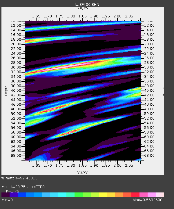
| Estimated Moho Depth: |
29.75 km |
| Estimated Crust Vp/Vs: |
1.76 |
| Assumed Crust Vp: |
6.459 km/s |
| Estimated Crust Vs: |
3.67 km/s |
| Estimated Crust Poisson's Ratio: |
0.26 |
|
| Radial Match: |
92.43313 % |
| Radial Bump: |
295 |
| Transverse Match: |
80.07276 % |
| Transverse Bump: |
400 |
| SOD ConfigId: |
2459 |
| Insert Time: |
2010-03-04 20:36:47.580 +0000 |
| GWidth: |
2.5 |
| Max Bumps: |
400 |
| Tol: |
0.001 |
|

Signal To Noise
| Channel | StoN | STA | LTA |
| IU:SFJ:00:BHN:20040405T21:34:10.473022Z | 16.72485 | 2.0098605E-6 | 1.201721E-7 |
| IU:SFJ:00:BHE:20040405T21:34:10.473022Z | 11.587311 | 2.510131E-6 | 2.1662758E-7 |
| IU:SFJ:00:BHZ:20040405T21:34:10.473022Z | 26.42879 | 7.704582E-6 | 2.915223E-7 |
| Arrivals |
| Ps | 3.6 SECOND |
| PpPs | 12 SECOND |
| PsPs/PpSs | 16 SECOND |


