You are here: Home > Network List > IU - Global Seismograph Network (GSN - IRIS/USGS) Stations List
> Station SFJ Sondre Stromfjord, Greenland > Earthquake Result Viewer
SFJ Sondre Stromfjord, Greenland - Earthquake Result Viewer
| Earthquake location: |
Southeast Of Taiwan |
| Earthquake latitude/longitude: |
22.3/125.3 |
| Earthquake time(UTC): |
1998/05/03 (123) 23:30:21 GMT |
| Earthquake Depth: |
33 km |
| Earthquake Magnitude: |
6.4 MB, 7.3 MS, 7.5 UNKNOWN, 7.5 ME |
| Earthquake Catalog/Contributor: |
WHDF/NEIC |
|
| Network: |
IU Global Seismograph Network (GSN - IRIS/USGS) |
| Station: |
SFJ Sondre Stromfjord, Greenland |
| Lat/Lon: |
67.00 N/50.62 W |
| Elevation: |
365 m |
|
| Distance: |
90.9 deg |
| Az: |
358.399 deg |
| Baz: |
3.775 deg |
| Ray Param: |
0.041635163 |
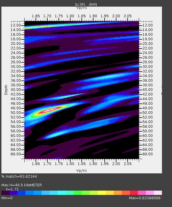
| Estimated Moho Depth: |
48.5 km |
| Estimated Crust Vp/Vs: |
1.71 |
| Assumed Crust Vp: |
6.459 km/s |
| Estimated Crust Vs: |
3.777 km/s |
| Estimated Crust Poisson's Ratio: |
0.24 |
|
| Radial Match: |
93.62344 % |
| Radial Bump: |
400 |
| Transverse Match: |
68.74124 % |
| Transverse Bump: |
400 |
| SOD ConfigId: |
4480 |
| Insert Time: |
2010-03-04 20:36:49.301 +0000 |
| GWidth: |
2.5 |
| Max Bumps: |
400 |
| Tol: |
0.001 |
|

Signal To Noise
| Channel | StoN | STA | LTA |
| IU:SFJ: :BHN:19980503T23:42:51.040015Z | 3.5317974 | 6.378428E-7 | 1.8060005E-7 |
| IU:SFJ: :BHE:19980503T23:42:51.040015Z | 1.1059039 | 3.3021223E-7 | 2.9859035E-7 |
| IU:SFJ: :BHZ:19980503T23:42:51.040015Z | 0.76339275 | 2.9483874E-7 | 3.862216E-7 |
| Arrivals |
| Ps | 5.4 SECOND |
| PpPs | 20 SECOND |
| PsPs/PpSs | 25 SECOND |


