You are here: Home > Network List > AV - Alaska Volcano Observatory Stations List
> Station MNAT Nateekin Bay, Makushin Volcano, Alaska > Earthquake Result Viewer
MNAT Nateekin Bay, Makushin Volcano, Alaska - Earthquake Result Viewer
| Earthquake location: |
Irian Jaya Region, Indonesia |
| Earthquake latitude/longitude: |
-0.6/131.3 |
| Earthquake time(UTC): |
2015/09/24 (267) 15:53:28 GMT |
| Earthquake Depth: |
24 km |
| Earthquake Magnitude: |
6.6 MWW, 6.4 MWB, 6.9 MI |
| Earthquake Catalog/Contributor: |
NEIC PDE/NEIC COMCAT |
|
| Network: |
AV Alaska Volcano Observatory |
| Station: |
MNAT Nateekin Bay, Makushin Volcano, Alaska |
| Lat/Lon: |
53.88 N/166.69 W |
| Elevation: |
390 m |
|
| Distance: |
74.4 deg |
| Az: |
32.886 deg |
| Baz: |
246.503 deg |
| Ray Param: |
0.052317303 |
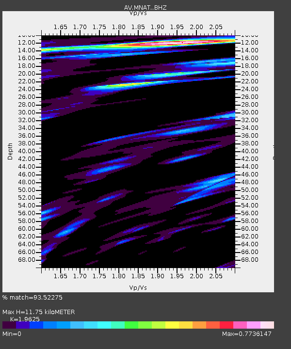
| Estimated Moho Depth: |
11.75 km |
| Estimated Crust Vp/Vs: |
1.96 |
| Assumed Crust Vp: |
3.943 km/s |
| Estimated Crust Vs: |
2.009 km/s |
| Estimated Crust Poisson's Ratio: |
0.32 |
|
| Radial Match: |
93.52275 % |
| Radial Bump: |
400 |
| Transverse Match: |
81.428406 % |
| Transverse Bump: |
400 |
| SOD ConfigId: |
7422571 |
| Insert Time: |
2019-04-21 00:23:01.419 +0000 |
| GWidth: |
2.5 |
| Max Bumps: |
400 |
| Tol: |
0.001 |
|
Signal To Noise
| Channel | StoN | STA | LTA |
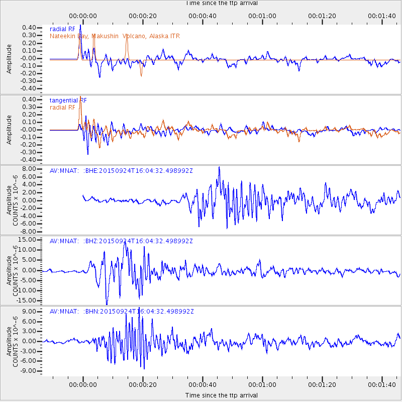
| AV:MNAT: :BHZ:20150924T16:04:32.498992Z | 5.52821 | 2.6292653E-6 | 4.756088E-7 |
| AV:MNAT: :BHN:20150924T16:04:32.498992Z | 2.616855 | 7.2576535E-7 | 2.773426E-7 |
| AV:MNAT: :BHE:20150924T16:04:32.498992Z | 2.2881622 | 8.6833967E-7 | 3.7949218E-7 |
| Arrivals |
| Ps | 2.9 SECOND |
| PpPs | 8.7 SECOND |
| PsPs/PpSs | 12 SECOND |


