You are here: Home > Network List > AV - Alaska Volcano Observatory Stations List
> Station SPCR Ckakachatna River, Mount Spurr, Alaska > Earthquake Result Viewer
SPCR Ckakachatna River, Mount Spurr, Alaska - Earthquake Result Viewer
| Earthquake location: |
Irian Jaya Region, Indonesia |
| Earthquake latitude/longitude: |
-0.6/131.3 |
| Earthquake time(UTC): |
2015/09/24 (267) 15:53:28 GMT |
| Earthquake Depth: |
24 km |
| Earthquake Magnitude: |
6.6 MWW, 6.4 MWB, 6.9 MI |
| Earthquake Catalog/Contributor: |
NEIC PDE/NEIC COMCAT |
|
| Network: |
AV Alaska Volcano Observatory |
| Station: |
SPCR Ckakachatna River, Mount Spurr, Alaska |
| Lat/Lon: |
61.20 N/152.21 W |
| Elevation: |
984 m |
|
| Distance: |
84.1 deg |
| Az: |
28.259 deg |
| Baz: |
257.872 deg |
| Ray Param: |
0.045710303 |
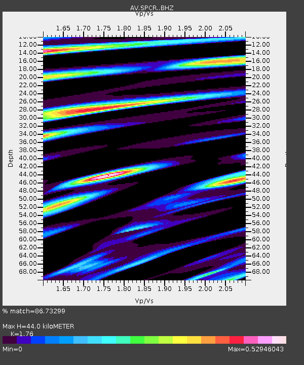
| Estimated Moho Depth: |
44.0 km |
| Estimated Crust Vp/Vs: |
1.76 |
| Assumed Crust Vp: |
6.566 km/s |
| Estimated Crust Vs: |
3.731 km/s |
| Estimated Crust Poisson's Ratio: |
0.26 |
|
| Radial Match: |
86.73299 % |
| Radial Bump: |
400 |
| Transverse Match: |
83.20962 % |
| Transverse Bump: |
400 |
| SOD ConfigId: |
7422571 |
| Insert Time: |
2019-04-21 00:23:11.717 +0000 |
| GWidth: |
2.5 |
| Max Bumps: |
400 |
| Tol: |
0.001 |
|

Signal To Noise
| Channel | StoN | STA | LTA |
| AV:SPCR: :BHZ:20150924T16:05:25.03897Z | 7.5252924 | 1.7545933E-6 | 2.3315948E-7 |
| AV:SPCR: :BHN:20150924T16:05:25.03897Z | 1.3065869 | 2.800342E-7 | 2.1432497E-7 |
| AV:SPCR: :BHE:20150924T16:05:25.03897Z | 1.3806992 | 2.6927174E-7 | 1.9502563E-7 |
| Arrivals |
| Ps | 5.2 SECOND |
| PpPs | 18 SECOND |
| PsPs/PpSs | 23 SECOND |


