You are here: Home > Network List > CN - Canadian National Seismograph Network Stations List
> Station INK INUVIK, NT > Earthquake Result Viewer
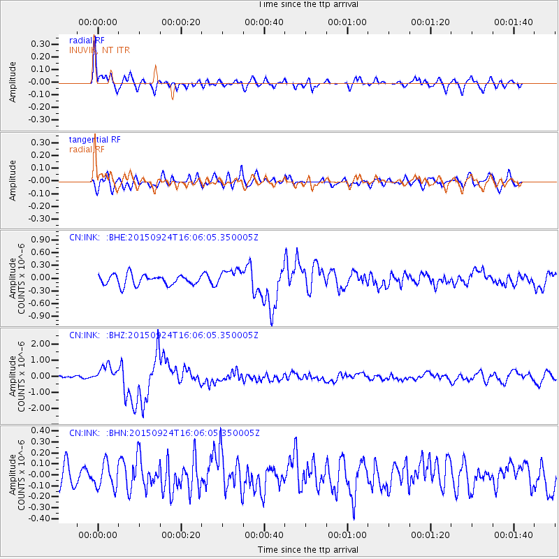
INK INUVIK, NT - Earthquake Result Viewer
*The percent match for this event was below the threshold and hence no stack was calculated.
| Earthquake location: |
Irian Jaya Region, Indonesia |
| Earthquake latitude/longitude: |
-0.6/131.3 |
| Earthquake time(UTC): |
2015/09/24 (267) 15:53:28 GMT |
| Earthquake Depth: |
24 km |
| Earthquake Magnitude: |
6.6 MWW, 6.4 MWB, 6.9 MI |
| Earthquake Catalog/Contributor: |
NEIC PDE/NEIC COMCAT |
|
| Network: |
CN Canadian National Seismograph Network |
| Station: |
INK INUVIK, NT |
| Lat/Lon: |
68.31 N/133.53 W |
| Elevation: |
44 m |
|
| Distance: |
92.5 deg |
| Az: |
21.753 deg |
| Baz: |
274.616 deg |
| Ray Param: |
$rayparam |
*The percent match for this event was below the threshold and hence was not used in the summary stack. |
|
| Radial Match: |
79.09916 % |
| Radial Bump: |
400 |
| Transverse Match: |
66.816605 % |
| Transverse Bump: |
400 |
| SOD ConfigId: |
7422571 |
| Insert Time: |
2019-04-21 00:23:17.384 +0000 |
| GWidth: |
2.5 |
| Max Bumps: |
400 |
| Tol: |
0.001 |
|
Signal To Noise
| Channel | StoN | STA | LTA |
| CN:INK: :BHZ:20150924T16:06:05.350005Z | 4.2437425 | 5.3858446E-7 | 1.2691261E-7 |
| CN:INK: :BHN:20150924T16:06:05.350005Z | 1.1497442 | 1.1551338E-7 | 1.0046877E-7 |
| CN:INK: :BHE:20150924T16:06:05.350005Z | 1.829403 | 2.2089594E-7 | 1.2074756E-7 |
| Arrivals |
| Ps | |
| PpPs | |
| PsPs/PpSs | |


