You are here: Home > Network List > ER - Mount Erebus Volcano Observatory Seismic Network Stations List
> Station ICE Mt Erebus site ICE > Earthquake Result Viewer
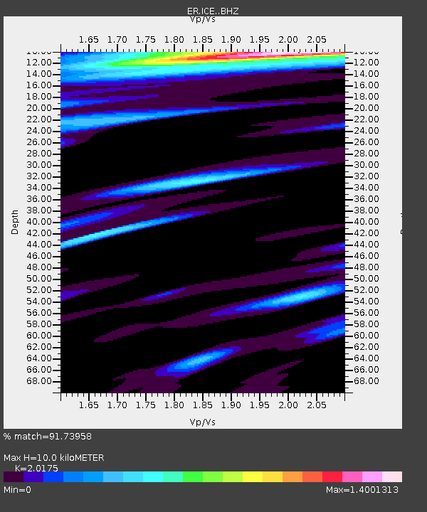
ICE Mt Erebus site ICE - Earthquake Result Viewer
| Earthquake location: |
Irian Jaya Region, Indonesia |
| Earthquake latitude/longitude: |
-0.6/131.3 |
| Earthquake time(UTC): |
2015/09/24 (267) 15:53:28 GMT |
| Earthquake Depth: |
24 km |
| Earthquake Magnitude: |
6.6 MWW, 6.4 MWB, 6.9 MI |
| Earthquake Catalog/Contributor: |
NEIC PDE/NEIC COMCAT |
|
| Network: |
ER Mount Erebus Volcano Observatory Seismic Network |
| Station: |
ICE Mt Erebus site ICE |
| Lat/Lon: |
77.55 S/167.28 E |
| Elevation: |
2370 m |
|
| Distance: |
79.3 deg |
| Az: |
172.538 deg |
| Baz: |
323.23 deg |
| Ray Param: |
0.049044747 |
| Estimated Moho Depth: |
10.0 km |
| Estimated Crust Vp/Vs: |
2.02 |
| Assumed Crust Vp: |
6.183 km/s |
| Estimated Crust Vs: |
3.064 km/s |
| Estimated Crust Poisson's Ratio: |
0.34 |
|
| Radial Match: |
91.73958 % |
| Radial Bump: |
400 |
| Transverse Match: |
87.84075 % |
| Transverse Bump: |
400 |
| SOD ConfigId: |
7422571 |
| Insert Time: |
2019-04-21 00:23:20.977 +0000 |
| GWidth: |
2.5 |
| Max Bumps: |
400 |
| Tol: |
0.001 |
|

Signal To Noise
| Channel | StoN | STA | LTA |
| ER:ICE: :BHZ:20150924T16:04:59.899016Z | 7.7703485 | 9.876087E-7 | 1.2709967E-7 |
| ER:ICE: :BHN:20150924T16:04:59.899016Z | 2.554373 | 3.3239147E-7 | 1.3012644E-7 |
| ER:ICE: :BHE:20150924T16:04:59.899016Z | 1.3628503 | 2.8917103E-7 | 2.1218106E-7 |
| Arrivals |
| Ps | 1.7 SECOND |
| PpPs | 4.8 SECOND |
| PsPs/PpSs | 6.5 SECOND |


