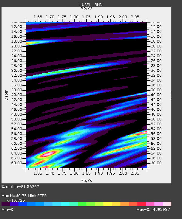
SFJ Sondre Stromfjord, Greenland - Earthquake Result Viewer

Earthquake location: Afghanistan-Tajikistan Bord Reg.
Earthquake latitude/longitude: 37.1/70.1
Earthquake time(UTC): 1998/05/30 (150) 06:22:28 GMT
Earthquake Depth: 33 km
Earthquake Magnitude: 5.9 MB, 6.9 MS, 6.6 UNKNOWN, 6.5 MW
Earthquake Catalog/Contributor: WHDF/NEIC
Network: IU Global Seismograph Network (GSN - IRIS/USGS)
Station: SFJ Sondre Stromfjord, Greenland
Lat/Lon: 67.00 N/50.62 W
Elevation: 365 m
Distance: 66.9 deg
Az: 338.456 deg
Baz: 48.329 deg
Ray Param: 0.057235923
Estimated Moho Depth: 69.75 km
Estimated Crust Vp/Vs: 1.67
Assumed Crust Vp: 6.459 km/s
Estimated Crust Vs: 3.862 km/s
Estimated Crust Poisson's Ratio: 0.22
Radial Match: 81.55367 %
Radial Bump: 400
Transverse Match: 81.68761 %
Transverse Bump: 400
SOD ConfigId: 4480
Insert Time: 2010-03-04 20:37:04.033 +0000
GWidth: 2.5
Max Bumps: 400
Tol: 0.001

Signal To Noise

ChannelStoNSTALTA
IU:SFJ: :BHN:19980530T06:32:47.189001Z4.10819443.5906234E-78.740149E-8
IU:SFJ: :BHE:19980530T06:32:47.189001Z0.92826541.1050557E-71.1904523E-7
IU:SFJ: :BHZ:19980530T06:32:47.189001Z1.6275692.173727E-71.3355667E-7
Arrivals
Ps7.6 SECOND
PpPs28 SECOND
PsPs/PpSs35 SECOND