You are here: Home > Network List > IU - Global Seismograph Network (GSN - IRIS/USGS) Stations List
> Station SFJ Sondre Stromfjord, Greenland > Earthquake Result Viewer
SFJ Sondre Stromfjord, Greenland - Earthquake Result Viewer
| Earthquake location: |
Southern Alaska |
| Earthquake latitude/longitude: |
60.5/-153.2 |
| Earthquake time(UTC): |
1998/07/09 (190) 19:39:43 GMT |
| Earthquake Depth: |
145 km |
| Earthquake Magnitude: |
5.3 MB, 6.2 UNKNOWN, 6.2 MW |
| Earthquake Catalog/Contributor: |
WHDF/NEIC |
|
| Network: |
IU Global Seismograph Network (GSN - IRIS/USGS) |
| Station: |
SFJ Sondre Stromfjord, Greenland |
| Lat/Lon: |
67.00 N/50.62 W |
| Elevation: |
365 m |
|
| Distance: |
40.8 deg |
| Az: |
35.932 deg |
| Baz: |
312.412 deg |
| Ray Param: |
0.07363577 |
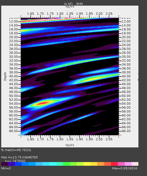
| Estimated Moho Depth: |
10.75 km |
| Estimated Crust Vp/Vs: |
1.75 |
| Assumed Crust Vp: |
6.459 km/s |
| Estimated Crust Vs: |
3.696 km/s |
| Estimated Crust Poisson's Ratio: |
0.26 |
|
| Radial Match: |
89.78331 % |
| Radial Bump: |
400 |
| Transverse Match: |
63.770405 % |
| Transverse Bump: |
400 |
| SOD ConfigId: |
4480 |
| Insert Time: |
2010-03-04 20:37:11.261 +0000 |
| GWidth: |
2.5 |
| Max Bumps: |
400 |
| Tol: |
0.001 |
|

Signal To Noise
| Channel | StoN | STA | LTA |
| IU:SFJ: :BHN:19980709T19:46:40.725989Z | 3.6276524 | 5.5447697E-7 | 1.5284733E-7 |
| IU:SFJ: :BHE:19980709T19:46:40.725989Z | 1.3318944 | 3.3985427E-7 | 2.5516607E-7 |
| IU:SFJ: :BHZ:19980709T19:46:40.725989Z | 1.3480096 | 4.6338576E-7 | 3.4375554E-7 |
| Arrivals |
| Ps | 1.3 SECOND |
| PpPs | 4.3 SECOND |
| PsPs/PpSs | 5.6 SECOND |


