You are here: Home > Network List > TM - Thai Seismic Monitoring Network Stations List
> Station LOEI LOEI staion > Earthquake Result Viewer
LOEI LOEI staion - Earthquake Result Viewer
| Earthquake location: |
Irian Jaya Region, Indonesia |
| Earthquake latitude/longitude: |
-0.6/131.3 |
| Earthquake time(UTC): |
2015/09/24 (267) 15:53:28 GMT |
| Earthquake Depth: |
24 km |
| Earthquake Magnitude: |
6.6 MWW, 6.4 MWB, 6.9 MI |
| Earthquake Catalog/Contributor: |
NEIC PDE/NEIC COMCAT |
|
| Network: |
TM Thai Seismic Monitoring Network |
| Station: |
LOEI LOEI staion |
| Lat/Lon: |
17.51 N/101.62 E |
| Elevation: |
305 m |
|
| Distance: |
34.3 deg |
| Az: |
303.143 deg |
| Baz: |
118.669 deg |
| Ray Param: |
0.07778102 |
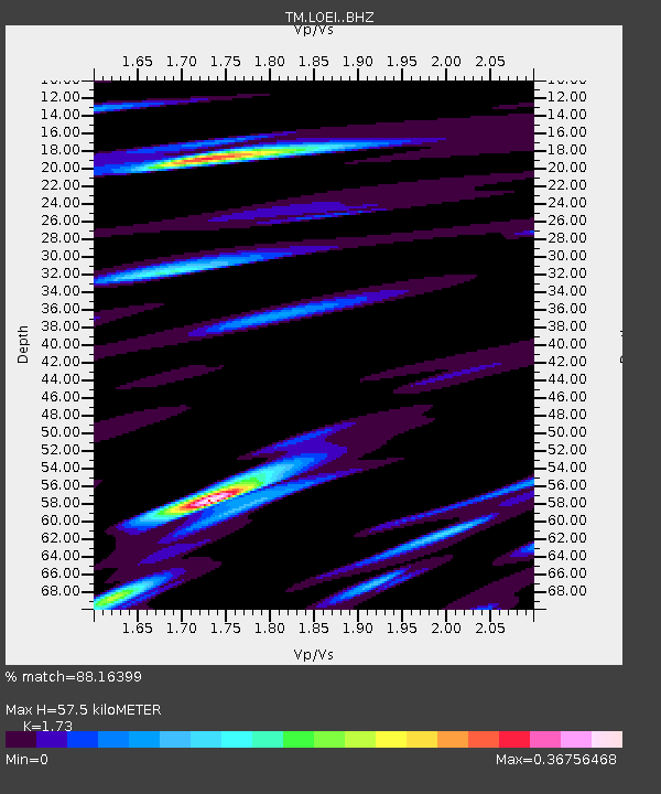
| Estimated Moho Depth: |
57.5 km |
| Estimated Crust Vp/Vs: |
1.73 |
| Assumed Crust Vp: |
6.35 km/s |
| Estimated Crust Vs: |
3.671 km/s |
| Estimated Crust Poisson's Ratio: |
0.25 |
|
| Radial Match: |
88.16399 % |
| Radial Bump: |
400 |
| Transverse Match: |
80.34915 % |
| Transverse Bump: |
311 |
| SOD ConfigId: |
7422571 |
| Insert Time: |
2019-04-21 00:25:20.788 +0000 |
| GWidth: |
2.5 |
| Max Bumps: |
400 |
| Tol: |
0.001 |
|

Signal To Noise
| Channel | StoN | STA | LTA |
| TM:LOEI: :BHZ:20150924T15:59:41.45999Z | 4.487044 | 3.6488843E-6 | 8.132045E-7 |
| TM:LOEI: :BHN:20150924T15:59:41.45999Z | 1.5926985 | 1.0581791E-6 | 6.6439395E-7 |
| TM:LOEI: :BHE:20150924T15:59:41.45999Z | 7.0755873 | 1.8746874E-6 | 2.649515E-7 |
| Arrivals |
| Ps | 7.1 SECOND |
| PpPs | 23 SECOND |
| PsPs/PpSs | 30 SECOND |


