You are here: Home > Network List > TM - Thai Seismic Monitoring Network Stations List
> Station SKLT SKLT SongKhla Phase1 > Earthquake Result Viewer
SKLT SKLT SongKhla Phase1 - Earthquake Result Viewer
| Earthquake location: |
Irian Jaya Region, Indonesia |
| Earthquake latitude/longitude: |
-0.6/131.3 |
| Earthquake time(UTC): |
2015/09/24 (267) 15:53:28 GMT |
| Earthquake Depth: |
24 km |
| Earthquake Magnitude: |
6.6 MWW, 6.4 MWB, 6.9 MI |
| Earthquake Catalog/Contributor: |
NEIC PDE/NEIC COMCAT |
|
| Network: |
TM Thai Seismic Monitoring Network |
| Station: |
SKLT SKLT SongKhla Phase1 |
| Lat/Lon: |
7.18 N/100.62 E |
| Elevation: |
4.0 m |
|
| Distance: |
31.5 deg |
| Az: |
284.777 deg |
| Baz: |
102.993 deg |
| Ray Param: |
0.07900746 |
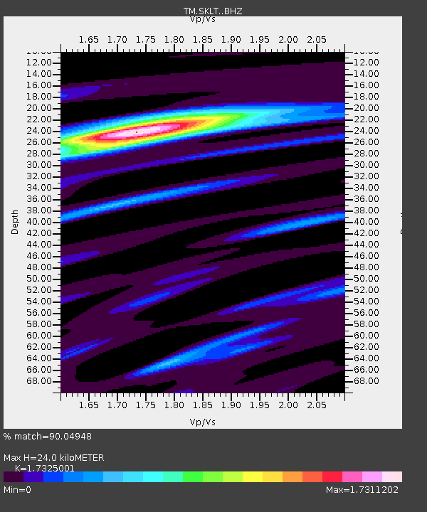
| Estimated Moho Depth: |
24.0 km |
| Estimated Crust Vp/Vs: |
1.73 |
| Assumed Crust Vp: |
6.468 km/s |
| Estimated Crust Vs: |
3.733 km/s |
| Estimated Crust Poisson's Ratio: |
0.25 |
|
| Radial Match: |
90.04948 % |
| Radial Bump: |
322 |
| Transverse Match: |
71.596695 % |
| Transverse Bump: |
400 |
| SOD ConfigId: |
7422571 |
| Insert Time: |
2019-04-21 00:25:23.647 +0000 |
| GWidth: |
2.5 |
| Max Bumps: |
400 |
| Tol: |
0.001 |
|

Signal To Noise
| Channel | StoN | STA | LTA |
| TM:SKLT: :BHZ:20150924T15:59:17.429991Z | 17.019243 | 2.060864E-6 | 1.2109022E-7 |
| TM:SKLT: :BHN:20150924T15:59:17.429991Z | 1.0928808 | 1.2432035E-7 | 1.13754716E-7 |
| TM:SKLT: :BHE:20150924T15:59:17.429991Z | 14.477176 | 1.4397541E-6 | 9.944993E-8 |
| Arrivals |
| Ps | 3.0 SECOND |
| PpPs | 9.3 SECOND |
| PsPs/PpSs | 12 SECOND |


