You are here: Home > Network List > ZJ12 - Transantarctic Mountains Northern Network Stations List
> Station GRAW East Antarctica > Earthquake Result Viewer
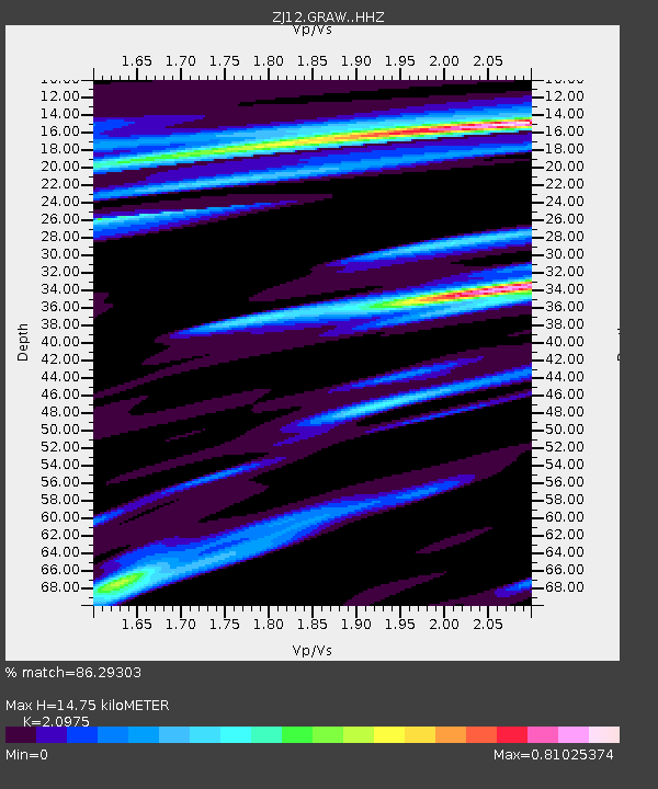
GRAW East Antarctica - Earthquake Result Viewer
| Earthquake location: |
Irian Jaya Region, Indonesia |
| Earthquake latitude/longitude: |
-0.6/131.3 |
| Earthquake time(UTC): |
2015/09/24 (267) 15:53:28 GMT |
| Earthquake Depth: |
24 km |
| Earthquake Magnitude: |
6.6 MWW, 6.4 MWB, 6.9 MI |
| Earthquake Catalog/Contributor: |
NEIC PDE/NEIC COMCAT |
|
| Network: |
ZJ Transantarctic Mountains Northern Network |
| Station: |
GRAW East Antarctica |
| Lat/Lon: |
74.00 S/154.99 E |
| Elevation: |
2205 m |
|
| Distance: |
74.7 deg |
| Az: |
173.355 deg |
| Baz: |
335.335 deg |
| Ray Param: |
0.052145828 |
| Estimated Moho Depth: |
14.75 km |
| Estimated Crust Vp/Vs: |
2.10 |
| Assumed Crust Vp: |
6.168 km/s |
| Estimated Crust Vs: |
2.941 km/s |
| Estimated Crust Poisson's Ratio: |
0.35 |
|
| Radial Match: |
86.29303 % |
| Radial Bump: |
276 |
| Transverse Match: |
84.04839 % |
| Transverse Bump: |
400 |
| SOD ConfigId: |
7422571 |
| Insert Time: |
2019-04-21 00:27:02.885 +0000 |
| GWidth: |
2.5 |
| Max Bumps: |
400 |
| Tol: |
0.001 |
|

Signal To Noise
| Channel | StoN | STA | LTA |
| ZJ:GRAW: :HHZ:20150924T16:04:34.089995Z | 3.4422476 | 1.5785213E-6 | 4.5857286E-7 |
| ZJ:GRAW: :HHN:20150924T16:04:34.089995Z | 0.651022 | 4.4350207E-7 | 6.812397E-7 |
| ZJ:GRAW: :HHE:20150924T16:04:34.089995Z | 1.2737254 | 4.779938E-7 | 3.7527226E-7 |
| Arrivals |
| Ps | 2.7 SECOND |
| PpPs | 7.2 SECOND |
| PsPs/PpSs | 9.9 SECOND |


