You are here: Home > Network List > US - United States National Seismic Network Stations List
> Station DUG Dugway, Tooele County, Utah, USA > Earthquake Result Viewer
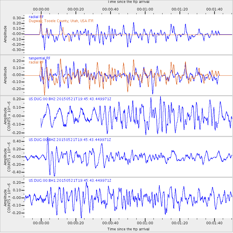
DUG Dugway, Tooele County, Utah, USA - Earthquake Result Viewer
*The percent match for this event was below the threshold and hence no stack was calculated.
| Earthquake location: |
Solomon Islands |
| Earthquake latitude/longitude: |
-9.8/160.3 |
| Earthquake time(UTC): |
2015/05/21 (141) 19:32:57 GMT |
| Earthquake Depth: |
10 km |
| Earthquake Magnitude: |
6.0 MWB |
| Earthquake Catalog/Contributor: |
NEIC PDE/NEIC COMCAT |
|
| Network: |
US United States National Seismic Network |
| Station: |
DUG Dugway, Tooele County, Utah, USA |
| Lat/Lon: |
40.19 N/112.81 W |
| Elevation: |
1477 m |
|
| Distance: |
93.8 deg |
| Az: |
50.046 deg |
| Baz: |
260.542 deg |
| Ray Param: |
$rayparam |
*The percent match for this event was below the threshold and hence was not used in the summary stack. |
|
| Radial Match: |
71.6329 % |
| Radial Bump: |
400 |
| Transverse Match: |
69.45437 % |
| Transverse Bump: |
400 |
| SOD ConfigId: |
976571 |
| Insert Time: |
2015-06-04 19:49:41.685 +0000 |
| GWidth: |
2.5 |
| Max Bumps: |
400 |
| Tol: |
0.001 |
|
Signal To Noise
| Channel | StoN | STA | LTA |
| US:DUG:00:BHZ:20150521T19:45:43.449971Z | 3.1657388 | 1.8281006E-7 | 5.774641E-8 |
| US:DUG:00:BH1:20150521T19:45:43.449971Z | 1.0071951 | 3.7203748E-8 | 3.6937973E-8 |
| US:DUG:00:BH2:20150521T19:45:43.449971Z | 0.83079845 | 5.988178E-8 | 7.2077384E-8 |
| Arrivals |
| Ps | |
| PpPs | |
| PsPs/PpSs | |


