You are here: Home > Network List > CI - Caltech Regional Seismic Network Stations List
> Station MPM Manuel Prospect Mine, California, USA > Earthquake Result Viewer
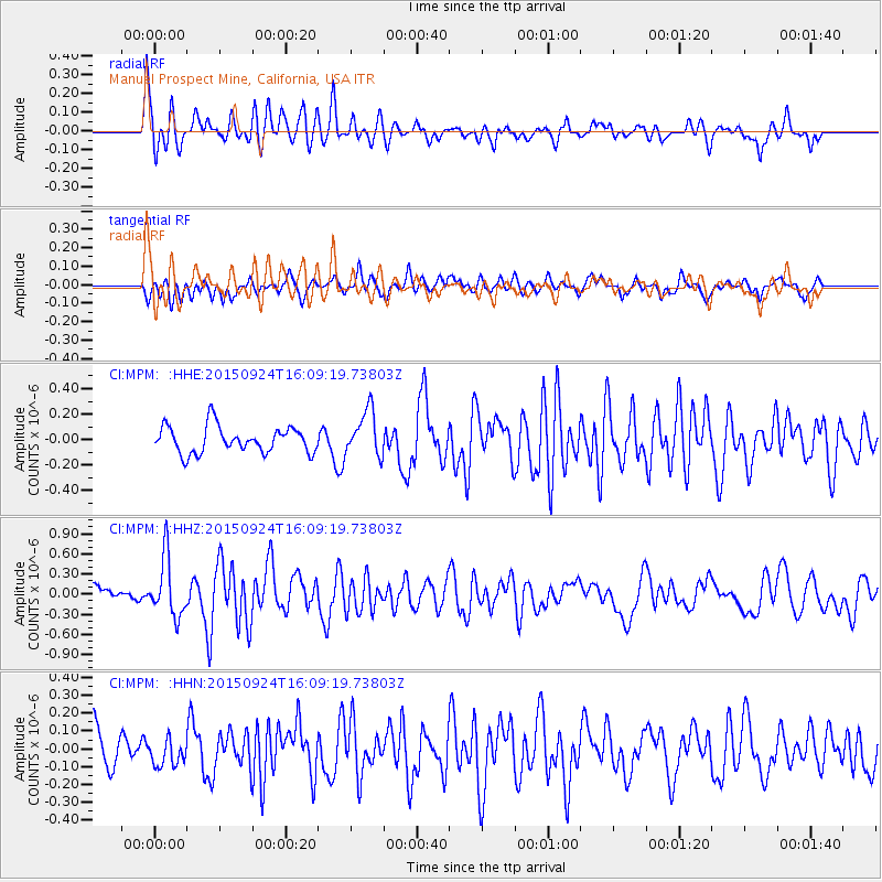
MPM Manuel Prospect Mine, California, USA - Earthquake Result Viewer
*The percent match for this event was below the threshold and hence no stack was calculated.
| Earthquake location: |
Solomon Islands |
| Earthquake latitude/longitude: |
-10.1/160.5 |
| Earthquake time(UTC): |
2015/09/24 (267) 15:56:57 GMT |
| Earthquake Depth: |
23 km |
| Earthquake Magnitude: |
6.0 MB |
| Earthquake Catalog/Contributor: |
NEIC PDE/NEIC COMCAT |
|
| Network: |
CI Caltech Regional Seismic Network |
| Station: |
MPM Manuel Prospect Mine, California, USA |
| Lat/Lon: |
36.06 N/117.49 W |
| Elevation: |
185 m |
|
| Distance: |
89.5 deg |
| Az: |
53.367 deg |
| Baz: |
257.175 deg |
| Ray Param: |
$rayparam |
*The percent match for this event was below the threshold and hence was not used in the summary stack. |
|
| Radial Match: |
73.98461 % |
| Radial Bump: |
400 |
| Transverse Match: |
52.081375 % |
| Transverse Bump: |
400 |
| SOD ConfigId: |
7422571 |
| Insert Time: |
2019-04-21 00:29:41.354 +0000 |
| GWidth: |
2.5 |
| Max Bumps: |
400 |
| Tol: |
0.001 |
|
Signal To Noise
| Channel | StoN | STA | LTA |
| CI:MPM: :HHZ:20150924T16:09:19.73803Z | 2.7415652 | 4.3254298E-7 | 1.5777228E-7 |
| CI:MPM: :HHN:20150924T16:09:19.73803Z | 0.8526684 | 7.20613E-8 | 8.451269E-8 |
| CI:MPM: :HHE:20150924T16:09:19.73803Z | 1.6927806 | 1.7678632E-7 | 1.0443545E-7 |
| Arrivals |
| Ps | |
| PpPs | |
| PsPs/PpSs | |


