You are here: Home > Network List > TA - USArray Transportable Network (new EarthScope stations) Stations List
> Station A36M Sachs Harbour, NT, CAN > Earthquake Result Viewer
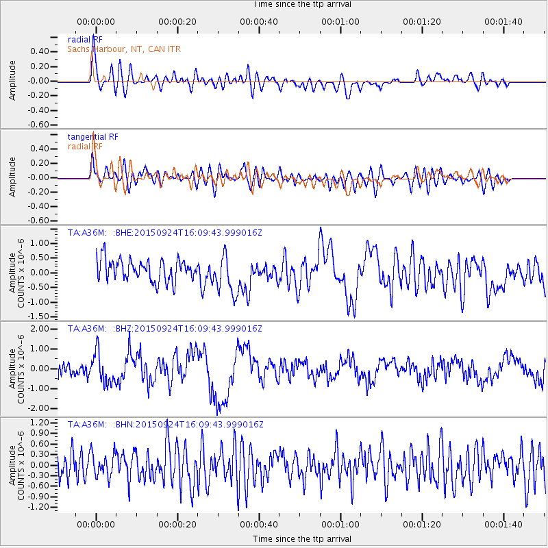
A36M Sachs Harbour, NT, CAN - Earthquake Result Viewer
*The percent match for this event was below the threshold and hence no stack was calculated.
| Earthquake location: |
Solomon Islands |
| Earthquake latitude/longitude: |
-10.1/160.5 |
| Earthquake time(UTC): |
2015/09/24 (267) 15:56:57 GMT |
| Earthquake Depth: |
23 km |
| Earthquake Magnitude: |
6.0 MB |
| Earthquake Catalog/Contributor: |
NEIC PDE/NEIC COMCAT |
|
| Network: |
TA USArray Transportable Network (new EarthScope stations) |
| Station: |
A36M Sachs Harbour, NT, CAN |
| Lat/Lon: |
71.99 N/125.25 W |
| Elevation: |
32 m |
|
| Distance: |
94.8 deg |
| Az: |
17.487 deg |
| Baz: |
251.98 deg |
| Ray Param: |
$rayparam |
*The percent match for this event was below the threshold and hence was not used in the summary stack. |
|
| Radial Match: |
69.75318 % |
| Radial Bump: |
400 |
| Transverse Match: |
58.649933 % |
| Transverse Bump: |
400 |
| SOD ConfigId: |
7422571 |
| Insert Time: |
2019-04-21 00:31:34.767 +0000 |
| GWidth: |
2.5 |
| Max Bumps: |
400 |
| Tol: |
0.001 |
|
Signal To Noise
| Channel | StoN | STA | LTA |
| TA:A36M: :BHZ:20150924T16:09:43.999016Z | 2.4894338 | 8.0295354E-7 | 3.2254465E-7 |
| TA:A36M: :BHN:20150924T16:09:43.999016Z | 0.7559051 | 3.0564186E-7 | 4.0433895E-7 |
| TA:A36M: :BHE:20150924T16:09:43.999016Z | 1.9513024 | 7.079489E-7 | 3.6280838E-7 |
| Arrivals |
| Ps | |
| PpPs | |
| PsPs/PpSs | |


